|
|
The primary objective of this website was originally to trace the Japanese presence in northwest Thailand during World War II. It was anticipated at that point that attention would necessarily "stray" from this objective to provide proper perspective, and indeed it has, as noted in the table below of subjects covered. A major emphasis of late has been locating and detailing aircraft crash sites in the region, as currently being developed under the topic, "Aircraft Losses, All Nationalities".
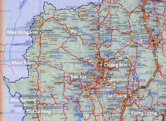
The subject area defined as northwest Thailand, originally covered just that shown in the map below:[1]
With the inclusion of aircraft crash events, the area has expanded as shown on the summary page for that topic.
Current subjects are available via these links, presented in alphabetical order:
| LOCATION
|
COMMENT |
Aircraft Losses
All Nationalities |
Details of about 50 aircraft lost during WWII in northwest Thailand (in process) |
Ban Kat
Burial Site |
About 40 minutes by road from Chiang Mai, this is the largest Japanese war memorial in northern Thailand. |
Chiang Mai
Don Kaeo Burial Sites
|
Nearly 400 wounded and sick Japanese who had survived the trek over the mountains from Mae Hong Son to two field hospitals here eventually died from exhaustion and disease. The gravesites remain unmarked. |
Chiang Mai
Wat Muen San
|
First Thai and then IJA troops were assigned at this wat less than a kilometer south of Chiang Mai Gate; the site served as a field hospital in the latter part of the war. |
Kaeng Luang
Railroad Bridge |
USAAF disabling of this bridge serving the IJA in north Thailand was costly to the Allies as well. |
Khun Yuam
Airstrip |
While the UK's official history tells that it was built after the war, the airstrip was, in fact, built during the war and probably by Japanese troops and Thai laborers working together. |
Lampang
Airfield Group
|
Lampang airfield with three satellite airstrips:
Hang Chat, Ko Kha, and Mae Mo. |
Lamphun
Airstrip |
It was used only by the Royal Thai Air Force. No evidence of it exists on the ground today. |
Lamphun:
San Khayom Bridge |
Damage from WW2 shells is still visible on it today
(unabridged version starts here). |
Lamphun:
Wat Phra Yuen |
Flying Tiger Ace Jack Newkirk was killed in a fiery crash in front of this wat in 1942. |
Mae Hong Son
Airstrip
|
Allied air attacks early in the war incorrectly assumed Japanese aircraft were based here to support Japan's invasion of Burma. |
| Mae Sariang Airstrip |
Allied orders for air attacks here early in the war vastly overestimated its importance. |
Mae Sariang
Tha Ta Fang
Old
Station House |
A minor border-crossing point into Thailand on the Salween River for Japanese troops retreating from Burma. |
| Pai:
Airstrip
|
The airstrip did not exist until after WWII. |
| Pai: WWII Bridge
|
Despite long-accepted tradition that it was built by the Japanese Army during WWII, it was not. |
| Tanaka |
Japanese photographer
in Northern Thailand 1909-1961 |
Maps
and
Aerial photography |
Map Resources
Williams-Hunt Aerial Photograph Digital Collection
USAAF Aerial Photo Intelligence
|
| Miscellaneous |
Saharat Thai Doem: WW2 Veteran
Chiang Rai: Air Facilities Review
Chiang Rai: Bertel Thorvaldsen
Lampang: Khun Tan Mountain Middle Railway Bridge
Yunnanyi, China: Airbases |
| Off-Topic:
Old Chiang Mai City Walls & Gates |
This is an old "working paper", which has not been properly referenced as yet. |
Off-Topic
Locating Loiwing |
Loiwing airstrip in western-most Yunnan, China, used briefly by the Flying Tigers in early 1942, is rediscovered. |
Preliminary notes
Land Route to Thailand |
IJA land route from east to Bangkok for supplies to Burma and the invasion of India. (old "working paper") |
This is but a small part of the total number of topics planned to be explored. But right now, listing only the developed subjects here will allow the average viewer quicker access to real content. It will save him having to wallow through a long list of mostly future topics to find the few currently developed ones.
Eventually an expanded index page, better organized, but also more informative, along the lines of this future home page, will give the viewer a more logical access to the website. The original list of topics planned for coverage is available at Annotated Table of Contents.
Note:
1.^ Map is extracted from แผนที่ทางหลวงประเทสไทย Scale: 1:1,600,000 (กรุงเทพมหานคร:กรมทางหลวง, 2009) [Road Map of Thailand, Scale 1:1,600,000 (Bangkok: Department of Public Highways, 2009)] (folded map). Annotations are by author using Microsoft Publisher.
Revision List
Topic additions & associated map changes not included
|
|
Rev
|
Date
|
Description
|
| 0 |
2010 Jun 11 |
First published on Internet. |
| 1 |
2012 Apr 30 |
Changed masthead photo. Replaced table of contents listing all subjects with listing only of major subject categories with links to separate webpages providing subcategory breakouts. Relocated single page table of contents to "Annotated Table of Contents". |
| 2 |
2012 Jun 10 |
Revised contents to be more "general". |
| 3 |
2012 Jul 07 |
Reduced contents list to only developed webpages. Simplified map. |
| 4 |
2012 Jul 29 |
Enhanced descriptions of developed topics. |
| 5 |
2014 Jan 06 |
Changed listing to alphabetical order. |
| 6 |
2014 Jun 16 |
Recoded home page. |
| 7 |
2015 Jul 13 |
Keyed alpha listing to general locations |
| 8 |
2020 Dec xx |
Website became unstable, to finally go offline in 2021 April. |
| 9 |
2021 Jul 28 |
This index page restored; linked pages to be uploaded one-by-one as reviewed. |
| 10 |
2022 May 24 |
Description of topics covered is expanded, eg, to cover aircraft crashes. |
|
|