| N19°54.415 E99°49.995[1] |
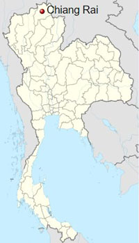
Chiang Rai Area Air Facilities Review | Chiang Rai[2] |
| Text | Notes | |||||||||||||||||||||||||||||||||||||||||||
|
April 1940: A Survey of Thailand (Siam) was published by the US War Department which included a listing of twenty-one significant air facilities. The report did not include Chiang Rai (nor Lampang nor Chiang Mai) in that list; but it did include Chiang Rai (and the other two) in a list of so-called "additional" air facilities:[4]
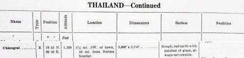
June 1941: The Airport Directory South East Asia included this entry for Chiang Rai:[5]
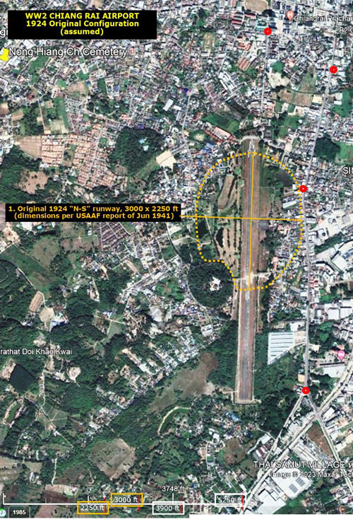
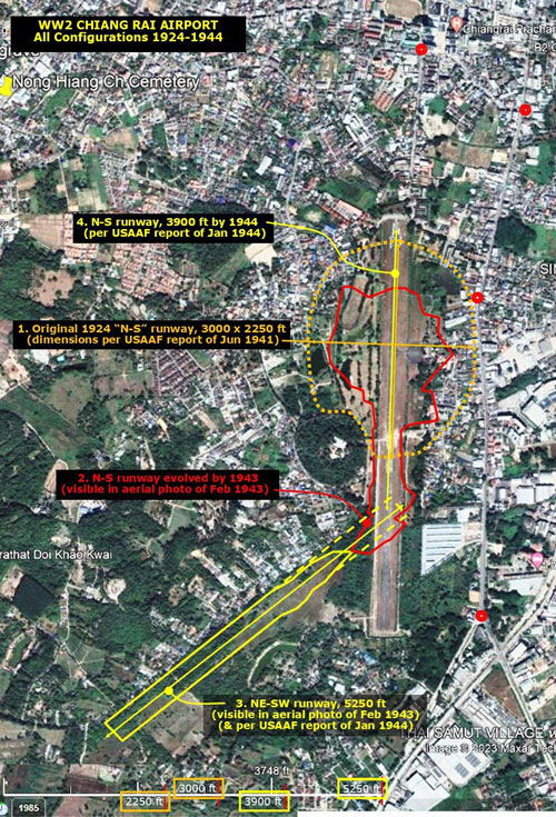
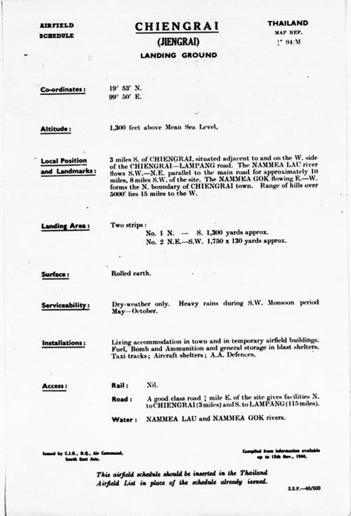
Type "E": Emergency fields (Military or Civil) either of small size or having few facilities or both [this definition included in reference]. The 1941 dimensions above are assumed to describe an oval airfield, 3000 ft in a N-S direction and 2250 ft in an E-W direction (based on the February 1943 aerial photo). The oval shape was common amongst early airports, such as Chiang Rai, which were often just large, flat, circular/oval fields with a wind sock, allowing aircraft to take-off or land into the wind --- whatever its direction. It is here assumed that the dimensions in 1941 were basically the same as those of the original airport in 1924.[6] The dimensions listed in June 1941 are laid out below on a Google Earth present-day satellite view of the airport area:[6a]
Dec 1941 - Aug 1945: Chiang Rai Airport is not listed as a target in the USAAF's chronology of the war;[6c] however, other areas in the town and province were targeted, particularly the steel truss one-lane road bridge over the Kok River.[6d] Note that the RAF did target Chiang Rai Airfield once, on 10 Feb 1942 (see below). 27 Dec 1941: RTAF Combined Wing 80, located in Prachinburi, was detached from the Eastern Combined Group to be relocated to Lampang, but during the move was diverted to Chiang Rai with three squadrons newly reassigned from other units: 22, 32, and 41.[6e] 04 Jan 1942: The combined wing began flying missions, consisting largely of recon over Shan States, observing Chinese troop movements between Kengtung and the Chinese border. 25 Jan 1942: A Japanese bomber unit was assigned to Chiang Rai to provide support against Allied attacks in the northern Thai region. Feb-Mar 1942: the combined wing flew bombing and photorecon sorties over Shan States east of the Salween River. 10 Feb 1942: Six Royal Air Force (RAF) Lysanders were recorded as having bombed Chiang Rai and Chiang Mai Airfields; with regard to Chiang Rai, however, while the airfield may have been targeted, records show that the Chiang Rai municipal building was actually hit, killing 14 Thai civilians.[6f] It is not clear whether the Lysanders were part of RAF Squadron 28 based in Mingaladon (Rangoon) or part of 1 Indian Air Force Squadron, possibly also out of Mingaladon.[6g] 13 Feb 1942: Combined Wing 80 was given responsibility for protecting both Chiang Rai and Chiang Mai. ~19 Feb 1942: Squadron 32 was detached from Combined Wing 80, leaving the wing with Squadrons 22 and 41. At some point, the wing had moved from Chiang Rai, but returned this date to Chiang Rai. 10 May 1942: The Royal Thai Army (RTA) advanced into the Shan States from northern Thailand. Combined Wing 80 flew close support for the RTA column proceeding directly up the Mae Sai Road to Kengtung. From this point on to the end of the war, Chiang Rai Airfield served as a forward operation base providing refueling for RTAF aircraft traffic between the Shan States and points south.[6h] 30 May 1942: Having occupied Kengtung on 28 May, Imperial Japanese Army (IJA) and RTA troops continued east to capture Mong Yawng. With this, offensive land operations effectively ceased with the arrival of the rainy season. The combined wing continued to provide support for RTA ground troops. Early July 1942: Squadrons 21 and 43 replaced 22 and 41 in Combined Wing 80, and the wing relocated to Kengtung, apparently ending RTAF and Imperial Japanese Army Air Force (IJAAF) use of the Chiang Rai Airfield as a homebase. August 1942: Chiang Rai appears on the border of the Aeronautical Chart: Irrawaddy River, (predecessor to present day TPC J-10B):[6i]
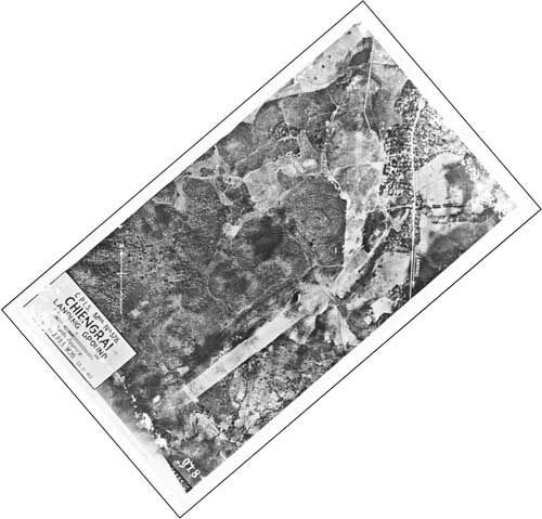
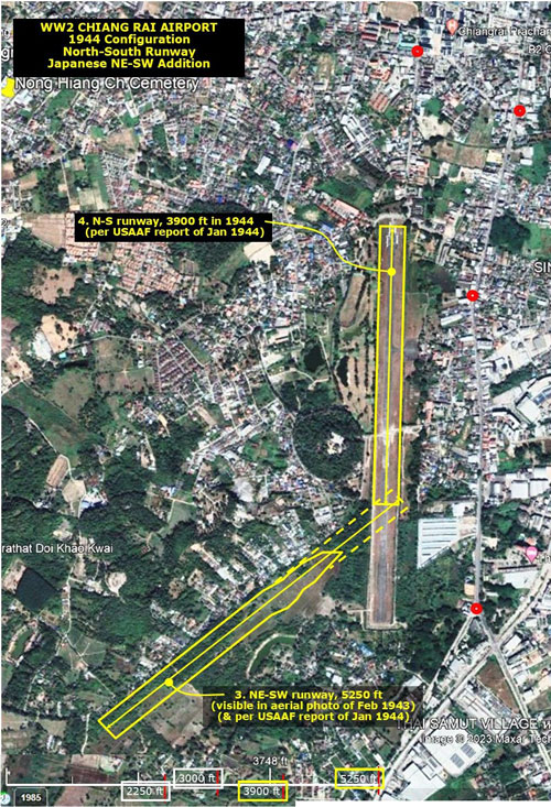
03 February 1943: Sometime prior to this date, Japanese forces had added a southwest-northeast runway off the south end of the existing north-south runway at Chiang Rai. Airfield Report No 15 (dated Oct 1943) displayed the first aerial photo of Chiang Rai airfield, which included the new IJAAF runway:[7]
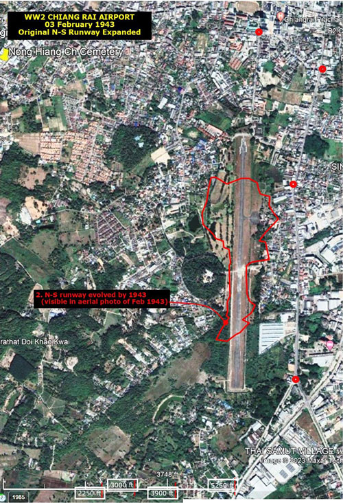
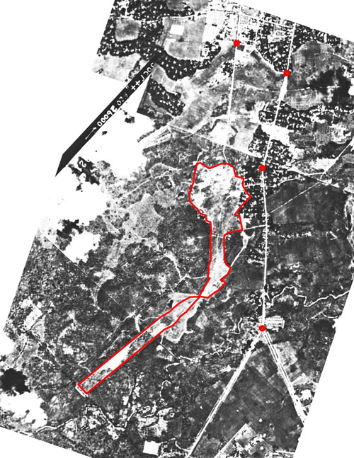
If the Chiang Rai airport configuration followed the normal evolution, after 1924 airport management would have recognized that local winds, ie, "prevailing winds", usually came from a very limited number of directions. Limiting the grooming of land to those directions would have proven more efficient than maintaining large oval/circular airfields, most areas of which pilots would never use. Increases in requirements for takeoff and landing lengths would have pressed airfield managers to trim back airfields to strips of land, airstrips, if you will. Increases in land costs and the expense of paving airstrips would have further motivated adopting an airstrip / runway approach. Hence, to the poorly defined oval seen in the overlay above, and based on dimensions dated June 1941, airport operations apparently subsequently added a southerly extension to the N-S runway as seen in this 1943 aerial photo sometime between January 1942 and February 1943. The red outline, traced from what is assumed to have been the N-S runway, was superimposed on a Google Earth satellite photo of the airport area. The outline appears to show a poorly maintained large oval area with a narrow 2000 ft long southerly extension:[8]
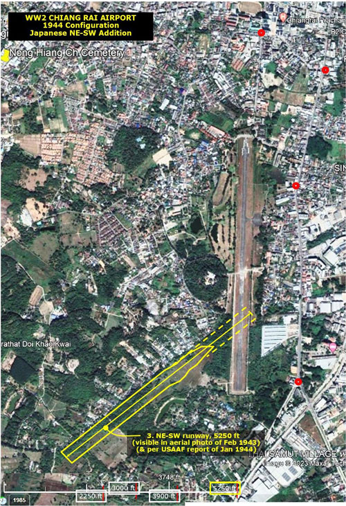
In addition, the Japanese constructed a separate runway in a NE-SW orientation as shown in the yellow outline below (the width is estimated at 300 feet (91 m), the same width as the current runway). The reason for building a separate, additional runway rather than merely improving the existing runway is not clear.[9]
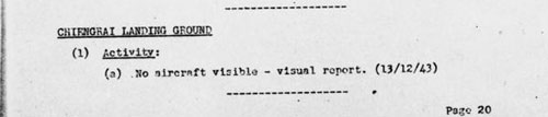
December 1943[10]
January 1944: A "miniature" of the runway configurations, standard on Allied publications for its pilots, shows Chiang Rai with two runways:[10a]
Transcription:
The outline of the information above is superimposed on the present-day satellite photo:[11]
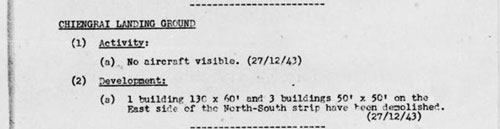
Another no action report:[11a]
Here is a composite of all the various configurations shown above:[12]
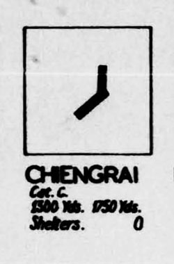
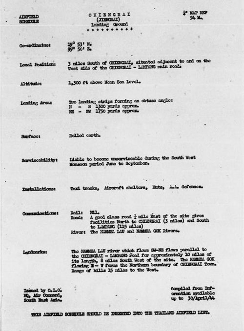
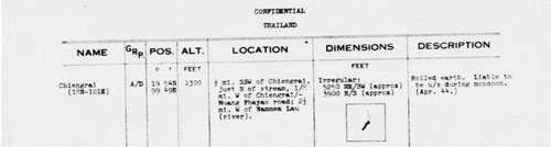
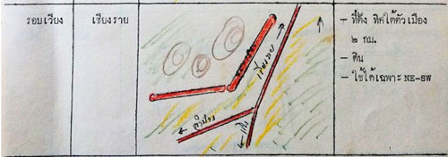
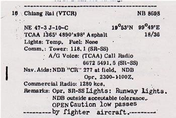
April 1944: A text description of the Chiang Rai runways adds some details not visible in the aerial photos:[13]
Notable in the description:
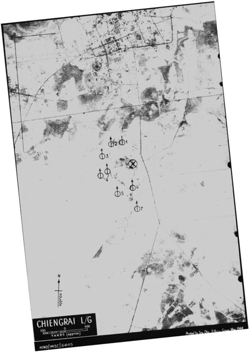
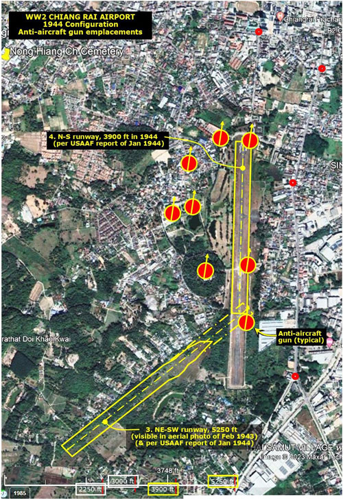
May 1944: Chiang Rai anti-aircraft defenses were identified on this Allied intelligence markup:[14]
And are superimposed on the 1944 map:[15]
July 1944: Basically the same information is provided here in a different format.[16]
05 October 1944: Some airfield activity, unusual, was noted in October 1944:[16a]
This is part of a mosaic of aerial photos of the Chiang Rai area in October 1944:[17]
Note: In preparing overlays for the present-day Google Earth sat view above, this 1944 aerial was used instead of the 1943 aerial because the earlier aerial didn't provide a sufficient number of identifiable points to tie the overlays to the present day sat view. The two photos were compared and found to be essentially the same in detail. However, the earlier photo does establish that the NE-SW runway was added after the Allied inventory of June 1941 and before February 1943. The red dots are the reference points, typically of easily identifiable street/road intersections which are used to align the old and new aerial photos.
November 1944[18]
Much the same information here was in the April 1944 report; but modifications include:
[Further monthly reports with basically the same information are omitted]
12 January 1945: The more normal situation, no activity, was reported:[20]
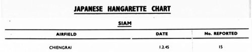
March 1945: "Hangarette" reporting was formalized:[21]
[Further Hangarette reports remain the same and are omitted]
26 May 1945: Rumored airfield activity was reported:[21a]
1954: From Maps of Airports Throughout the Kingdom of Thailand, the two runways are still presented:[22]
Labels on the three roads identify destinations:
Note that, in 1954, the North-South runway was unusable.
1971: However, by 1971, Air America listed only the North-South runway:[23]
1992
2018: The old airport was used as a helicopter landing base to support the Tham Luang cave rescue.[24c]
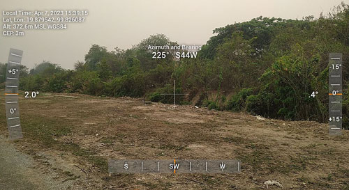
2023: Major expansion work is in progress at the new airport, with construction of an aircraft maintenance facility set to be completed by 31 July 2023. The facility will be able to service and repair large Airbus and Boeing aircraft from China. [24d] The old airport is now under a two year plan of development which is scheduled to end in 2025. It will serve as a hub for search and rescue (SAR) helicopters, reconnaissance aircraft, and unmanned aerial vehicles (UAVs).[24e] View looking roughly southwest from the old, still existing old north-south runway in the direction of the NE-SW airstrip constructed by IJA around 1942. The interface is completely overgrown (the photo was taken during the worst of air pollution; hence the brown cast to the sky and brown tones generally).[25]
Not shown here, but on our visit in April 2023, we saw several fire-fighting tanker helicopters near the north end of the old airport which had been brought in during the height of the burning season.[26]
|
References are provided in this column for the convenience of the reader. Please advise author of any errors. Readers are encouraged to copy this webpage for their own future reference. See How to Copy Webpages. These pages were composed to be viewed best with Google Chrome. Revision list. See bottom of Text column on this page. Bibliography supports notes. 1.^ Google Earth coordinates for approximate center of Muang Chiang Rai. 2.^ Note: Chiang Rai town, not province. 3.^ Wikipedia: Old Chiang Rai Airport gives 1926 as date of activation (without reference); however, Sakpinit Promthep advises that it first appears in RTAF records in Feb 1924 when the RTAF sent three Breguet 14 bombers for flight demonstrations to celebrate the opening of six new airfields in the north; the date for the visit to Chiang Rai was 24-27 Feb 1924. Further, in 1926, Chiang Rai was not the second airfield in Thailand as Wikipedia avers: there were four airports permitted at that time for commercial operation: Don Muang, Chiang Mai, Songkhla, and Ubon Ratchatani. (Sakpinit Promthep email to author of 0257 14 Jun 2023) 4.^ A Survey of Thailand (Siam) March 15, 1941 ([Washington]: War Department, 15 Mar 1941) Appendix I, v. Additional airdromes, landing grounds, and seaplane facilities (correct up to April 1940) 5.^ Airport Directory South East Asia (Washington: US Army Air Forces, 28 Jun 1942), p 14 (correct up to June 1941; reference needed). 6.^ "The world's first runways . . . were circular. . . . sometimes . . . early airports were square rather than round. Near my home is a large square park which was at one time just such a facility. It measured one mile on each side, and is today called “Mile Square Park”." (Ron Rapp, "The Circular Runway", apparently speaking of Orange County, California) 6a.^ Current Google Earth satellite image annotated by author using Microsoft Publisher. 6b.^ (deleted)
6c.^ Kit C Carter & Robert Mueller, U.S. Army Air Forces in World War II Combat Chronology 1941-1945 (Washington: Center for Air Force History, 1991) 6d.^ "Chiengrai bridge was bombed": Sitrep 10AF, 12 Dec 44 (USAF Archive Microfilm Reel A8044 p 0344) 6e.^ Unless otherwise noted, local event entries thru to "early July 1942" summarize the presentation in:
6f.^ Rebecca Weldon email to author of 14:07 09 Jul 2020. 6g.^ Christopher Shores, Biran Cull, Yasuho Izawa, Bloody Shambles Volume 2 (London: Grub Street, 1993), pp 263, 267.
6h.^ Sakpinit Promthep email to author 02:57 14 Jun 2023.
6i.^ Extract from Aeronautical Chart: Irrawaddy River (Washington: Army Map Service August 1942) (USAF Archive microfilm reel 25882 p0997) (see USAAF Aeronautical Charts Index Map and Irrawaddy River for complete map). Note that Chiang Rai is in the bottom margin of this map (roughly equivalent to present day Tactical Pilot Chart TPC J-10B): the adjacent aeronautical chart, 677, would show it in its main portion; but no copy of Map 677 for this date has been found. It is very roughly equivalent to the current Tactical Pilot Chart TPC J-10C
7.^ Airfield Report No 15 (issued by CIO, Air HQ, India, October 43), p 9 Note that photo itself is dated 03 February 1943, eight months before publication
8.^ Current Google Earth satellite image annotated by author using Microsoft Publisher.
9.^ Current Google Earth satellite image annotated by author using Microsoft Publisher.
10.^ Airfield Report No 17 (issued by Chief Intelligence Officer, HQ, Air Command, South East Asia, December 1943), Record of Airfield Activity and Development - Thailand, p 20
10a.^ Airfield Report No 17 (issued by Chief Intelligence Officer, HQ, Air Command, South East Asia, December 1943), Airfield Miniatures, no page no.
11.^ Current Google Earth satellite image annotated by author using Microsoft Publisher.
11a.^ Airfield Report No 18 ((issued by Chief Intelligence Officer, HQ, Air Command, South East Asia, 31 January 1944), Record of Airfield Activity and Development, p 26
12.^ Current Google Earth satellite image annotated by author using Microsoft Publisher.
13.^ Airfield Report No 21 (Apr 44), Section title page missing, no section page no.
14.^ Record of Japanese Anti Aircraft Defenses (CIO, HQ, Air Command, South East Asia, June 1944?), Thailand: Alphabetical List of Main Target Areas, (Chiang Rai image printed May 1944), no page no.
15.^ Current Google Earth satellite image annotated by author using Microsoft Publisher.
16.^ Provisional Airfield List, Southeast Asia, Report No 3 (Washington: Office of Ass't Chief of Staff, Intelligence, July 1944), p 59
16a.^ Airfield Report No 27 (Chief Intelligence Officer, HQ, Air Command, South East Asia, 31 Oct 1944), Record of Airfield Activity and Development, p 9 17.^ From: Williams-Hunt Aerial Photos Collection Photos were assembled by author using Microsoft ICE (Image Composition Editor). See additional comment at Chiang Rai Photomosaic. Mosaic has been oriented so that its north is to the top of the page.
18.^ Airfield Report No 18 (CIO, HQ, AIR SEAS, November 1944), no page nos.
19.^ (deleted)
20.^ Airfield Report No 30 (issued by Chief Intelligence Officer, HQ, Air Command, South East Asia, 31 Jan 1945), Record of Airfield Activity and Development, p 6 21.^ Airfield Report No 32 (issued by Chief Intelligence Officer, HQ, Air Command, South East Asia, 31 Mar 1945), Record of Airfield Activity and Development, no page no. 21a.^ Airfield Report No 34 (issued by Chief Intelligence Officer, HQ, Air Command, South East Asia, 31 May 1945), Record of Airfield Activity and Development, p 2
22.^ Document in Royal Thai Air Force Museum Library:
22a.^ Clarified in email from Edwin McKeithen, 20:29, 27 Jun 2023 to Bruce Kennedy.
23.^ Air Facilities Data Thailand 432 [aka "Tango"] (Bangkok(?): Air America, 01 Feb 1971), p 11
24.^ Wikipedia, Old Chiang Rai Airport
24a.^ Clarified in email from Sakpinit Promthep, 01:36am 27 Jul 2020 to author. As an "independent squadron", the unit is not currently fully operational: it is minimally manned to maintain facilities for air operations as needed.
24b.^ Wikipedia: Chiang Mai International Airport.
24c.^ Wikipedia: Old Chiang Rai Airport.
24d.^ Wikipedia: Chiang Rai International Airport.
24e.^ Sakpinit Promthep email 01:36 27 Jul 2020 to author.
25.^ Dioptra view
26.^ Edwin MeKeithen email, ibid. |
|||||||||||||||||||||||||||||||||||||||||||
 1924: The original Chiang Rai Airport was established by the Royal Thai Air Force (RTAF) at N19°53.29 E99°49.61; it was one of six in northern Thailand visited on an RTAF tour that year to celebrate the opening of new airfields in northern Thailand:
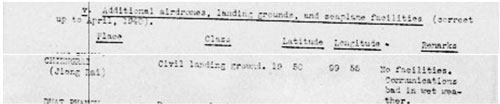
-Aug-42-extract-ptpt.jpg)

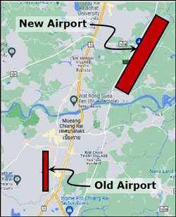 The commercial functions of the old airport were transferred to the new Chiang Rai International Airport (N19°57.13 E99°52.97).