Japan in Northwest Thailand during World War II
ww2northernthailand.com is now paralleling this website,
and will replace this website when it expires later this year
| N18°36.6 E98°48.8 |
Ban Kat[1] (Th: บ้านกาด / Jp: バンガート村) page 1 of 8 |
Route 1013 |
 |
|||
| Text | Notes | ||
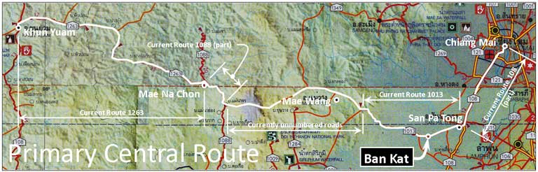
Ban Kat[2] was the second major stop on the Imperial Japanese Army (I J A) Central Route running easterly through Thailand from Khun Yuam to, first Mae Na Chon, then Ban Kat, and finally San Patong and Chiang Mai. Limited medical facilities were available at Ban Kat and, a few kilometers to the east, vehicles could pick up personnel for the trip to Chiang Mai. The vast majority of personnel took 13 days to traverse the 160 km to Ban Kat. Wat Muen San in Chiang Mai was another 30 km beyond.[2a] Relevant chronology for Ban Kat follows: 1890s (BE2430s) Teacher-monk Zaotamutein established Wat San Kayoum (N18°36.530 E93°48.770); the site included a water well.[3] 1913 (BE2456) At Zaotamutein's death, the wat with its well was abandoned.[4] 1913-1941 (BE 2456-2484) Following abandonment of the wat, Thai highway bandits who robbed and killed travelers, dumped the bodies of their victims down the abandoned well for old Wat San Kayom. In addition, the well became a favorite dump site for bodies resulting from local drug wars (which existed even back then); nationalities in this activity came to include not only Thais, but also Burmese and Jin Haw Chinese. Over time, a number of bodies accumulated; this, coupled with no maintenance, eventually filled the well in above the water table and it went dry.[5] 1941-1945 (BE 2484-2488)
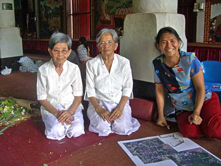
Source 1. Two sisters, Komloo and Yai Yin,[5b] then 15 and 18, and now continuing residents of Ban Kat, were present when portions of the Imperial Japanese Army (IJA), defeated at Imphal, India, retreated via the Central Military Supply Route which goes through the town.[6] With parents emigrated from Burma, their first language had been Burmese which was later supplanted by Taiyai. They grew up in a house on a lot along Bat Kat Soi 4/6.[7] which is now occupied by Komloo's house and shop (N18°35.865 E98°49.195).
A significant number of Ban Kat residents at that time were relocated Burmese. They congregated in the south of the town. The two active wats in that part of town, Chamlong and Umpharam, were manned by Burmese monks. Another wat --- long abandoned --- was Wat Maan, or Wat Muan To; the latter means "Burmese wat" in Burmese. The sisters maintain that a British administrative type was present in the village before the war to oversee interests of the Burmese there. They believed him to be a representative of the British colonial government in Burma; however, he would more likely have been an employee of one of the British logging companies.[8] In 1945, the sisters sold vegetables and noodles to Japanese soldiers at the local market which was located at the east end of their soi (N18°35.855 E98°49.235). Soldiers used rice.[9] and salt to barter for market goods; they did not have any medicines to trade (as some did back in Khun Yuam). The soldiers would combine everything they bought in large kettles, cook it up, and then dole it out with rice container lids. There was a lamyai plantation where the local market is today, directly across the street from Komloo's house. At that time, the street was just a dirt path. The general alignment of the main road serving Ban Kat, with connections immediately east and west, was the base for Thai Route 1013 today. The first time Yai Yin saw any Japanese was in 1945 when soldiers were returning from Burma. Neither sister recalls an IJA scouting party coming through the previous year to evaluate the suitability of the route for supporting the Japanese invasion of Imphal.[10]
|
See Key for interpreting page content. Revision list. See bottom of Text column on this page. 1.^ บ้านกาด, ie, Ban Kat, is the Royal Thai Survey Department (RTSD) place name. It is also rendered in English as Ban Kad, Ban Gat. 2.^ Map is composite from แผนที่ทางหลวงประเทสไทย For reference purposes, the route is here described using modern highway designations where applicable. From Toungoo in Burma on Burma Route 5 past Mawchi to Kemapyu; across the Salween River and onto trails not later improved into Thailand to Huai Tonnun (บ้านห้วยต้นนุ่น); from there on improved, unnumbered roads to Pratumuang (บ้านประตูเมือง); then via Thai Route 1337 to Khun Yuam (ขนยวม); then on Thai Route 1263 to Mae Na Chon (แม่นาจร); continuing on improved, unnumbered roads to Mae Wong (แม่วาง); then on Thai Route 1013 through Ban Kat to San Pa Tong (สันป่าฅอง); and finally north on Thai Route 108 to Chiang Mai. 2a.^ 160 km is derived from map on page 3. The 30 km comes from the 9+14 distances shown on that map which seem to end at Hang Dong (unnamed) plus a Google Earth path plot of approximately 7 km (Hang Dong to CNX Silver Wats.kml). 3.^ "Details about the Monument Dedicated to Those Left Behind in the Thai-Burma Theatre", Etou Foundation handout (undated, translated from Japanese). 4.^ ibid 5.^ Interview with Komloo and Yai Yin, lifelong residents of Ban Kat: with Kamloo on 29 Sep 2008 and with the two on 04 Oct 2009. Wiyada 'Noi' Kantarod was translator for both interviews. See below. 5a.^ In Thailand, Konishi Makoto (小西 誠) was a Japanese language teacher at the Ban Kat school. In that position, he became well acquainted with the unique historical content of Ban Kat relative to Japan and WWII. While maintaining his connections with the school, he took on responsibilities as manager of the Japanese War Memorial there. Since then, Konishi Makoto has resigned his teaching position, trained a replacement for his manager function, and resigned that function as well, to further his education. He continues to provide unique guidance in my efforts. He, in turn, had been 'discovered' by Junko Kobata Author photo: CIMG3668a.jpg, 5b.^ Family name missing. 6.^ See map near top of page. 7.^ Ban Kat Soi 4/6 in Tambon Mae Wang (บัานกาด ซอย 4/6 เทศบาลตำบลแม่วาง) 7a.^ Author photo: CIMG5018a.jpg, 04 Oct 2009. 8.^ The London Gazette makes no mention of the appointment of a representative at Ban Kat; in listing responsibilities of the British consul in Chiang Mai, it names several locations, including 'Chiengmai, Lampun, Mehongson, Lampang, Chiengrai, Phre, Nan and Utaradit' and adds that he is 'to reside in Chiang Mai' (London Gazette, issue 34494, p 1840, 18 Mar 1938). 9.^ Some rice had been donated by sympathetic Thais. Some had been received as essentially wage for having helped Thais, typically farmers. Some had been harvested by the soldiers themselves as they traveled. 10.^ Such can be assumed to have occurred in mid-1943 per 戦史叢書 Vol 15:インパール作戦―ビルマの防衛 (東京: 防衛庁防衛研修所戦史室 (編集), 1968年)[Senshi Sosho, vol 15: Imphal Maneuvers, Burma Defense (Tokyo: Defence Agency, National Defense College Military History Room, 1968)] , p 139. |
||