| Royal Thai Army WW2 Veteran of Saharat Thai Doem 1944-1945 |
| Text | Notes | |||||||||||||||||||||||||||||||||||||||||||||||||||||||||||||||||||||||||||||||||||||||||||||||||||||||||||||||||||||||||||||||||||||||||||||||||||||||||||||||||||||||||||||||||||
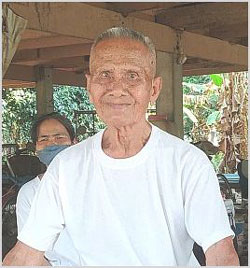
|
In addition, it is possible that he is the last surviving veteran of the RTA from WW2.
At the end of 1943,[11a] road construction / improvement work in Thailand's annexed Saharat Thai Doem was apparently still very much in progress, a year after Phibun's orders had been issued, and six months after his targeted completion date --- for the schedule for the work scope had been grossly unrealistic. As a consequence, the army, needing more workers for the roads projects, put out a call through local puyaibans (village headmen) for volunteers to join the RTA and go north into the Saharat to construct / improve roads. The only requirement for volunteers was to be under the age of 50; married status was irrelevant. There were so many volunteers that they were chosen by drawing straws. Feuay volunteered, won the draw, and joined the RTA to be assigned to Engineering Reserve Battalion 4. He was one of 80 troops, divided into four groups of twenty; while all were Thai, he recalls having difficulty in understanding the accent of those from the south. They all were trucked north from Uttaradit to standby in Lampang for four days, then on to Mae Sai and Kengtung on what he saw as well-maintained roads; after a wait of another four days in Kengtung, they were driven north on a narrow road to Nampong (น้ำปอง) on the Nampong River. The battalion's workscope was not the Mae Sai-Kengtung Road as we had thought; but was what he described as a road running east or northeasterly out of Kengtung towards Sibsongbanna (Xishuangbanna) in Yunnan, China.
Work turned out to be a seven day a week affair, each day ending about 4pm. Supervision was provided by someone with experienced in roadwork --- which none in the work groups had. The supervisor was the only one armed; and he used the weapon only once, trying to kill an inquisitive tiger; wild animals in general avoided the group because there were so many of them and they were quite noisy. No bandits were seen --- again the size of the group plus an assumption that, being army, they were well armed, probably detered them.
Cooks procured food stuff locally --- the single gun in the unit was not used for hunting; fuel for cooking and warmth in cold weather came from the scrap wood generated by their clearing efforts. The army provided clothing, as well as shelter described as individual "pup" tents, along with mosquito netting. While Feuay claimed the winter cold was tolerable --- there was no snow ---the army did supply blankets. Work would stop when it rained. Medical support was limited: quinine was available to treat malaria, but two workers in their group of 20 died of the disease in hospital in Kengtung; Feuay knew of deaths from malaria in the other groups. He was friendly with the supervisor and would accompany him when visiting the hospital in Kengtung where serious illnesses were treated. In the 20 months that they worked on the project, there was no mail, no communication with their families in Thailand. They were paid in Thai coin, four baht a month. That was considered adequate since the army supplied food, clothing, shelter. They encountered no Japanese, Chinese, or Westerners during their time in Kengtung State; local Burmese seemed happy having the Thai military around since they were spending money. The workers saw no airstrips or aircraft. They encountered no hostilities. There was some sort of warning system set up for air attacks, for which the solution was to hide in streambeds; Allied records list twelve attacks on Kengtung during the period January 1944 to January 1945, after which no more were recorded (see Appendix). But Feuay recalled no air attacks or even alerts at his project. They were unable to complete the road by Aug 1945, when the war ended, primarily because they were clearing woodland by hand --- slow, hard work. Feuay was unable to put a name on the location where they stopped; but said it wasn't as far as Bpa-faeg. At war's end, his unit was apparently abandoned by the army and troops had to walk from where work had stopped to Kengtung and then on to Mong Hpayak. From there the army trucked the group back to Lampang where they were again abandoned. There, they went to the railyard at night and hid in railway freight cars (box cars) for the trip south. Wisarut Bholsithi noted that some other Thai troops returning from the north were not so lucky and had to walk the whole way back home. They typically followed the railway tracks south from Lampang because the railway offered the most direct route. During their march south, they would be passed by passenger trains carrying Japanese POWs to camps around Bangkok. Which is to say, the Thai government treated Japanese POWs better than its own soldiers after the war ended.[13a] Comment: The details provided by Feuay are roughly in general agreement with those provided in the RTA History, except that the locations he mentioned don't appear on any map to which I have access. The language spoken in that part of Burma would have been readily understandable by Thais in the army, so there shouldn't have been any misunderstanding as to location names. However, those location names might have changed over 80 years. And the local versions of names of features that he was familiar with might not be the same as those that appear on official maps. And, unfortunately, we currently have no access to Burma to query local people about place names. APPENDICES Saga of the RTA Engineering Battalions in the North[13b] While beset by the arrival of an unusually wet rainy season in May 1942, the Thai army formally occupied Kengtung that June; however, the continual bad weather made quagmires of existing roadways and quickly halted the Thai effort to drive out Chinese troops east of Kengtung. With the road unpassable to motor transport, the army had to resort to elephants, horses, donkeys, mules to supply troops in the field; particularly critical was the delivery of quinine to treat malaria; the air force was enlisted to assist. In any case, Thai troops were not able to continue their offensive against the Chinese until early January 1943 and that was hindered by shortages which had become acute. The road conditions no doubt contributed to Phibun's decision in January to order an urgent and massive roads project in Saharat Thai Doem. From the time of Phibun's 1943 orders to build / improve roads associated with Saharat Thai Doem, the sole purpose of the three army engineering battalions, numbered 1, 3, and 4, transferred from the Phayap Army was roadwork. The battalions formed a minor part of a 15,000 man Transportation Building Brigade largely composed of civilians. The troops were provided hand tools, ie, shovels, hoes, picks, buckets, axes, knives, saws --- which Feuay alluded to. And were nominally provided with power-saving machinery for excavation, cutting, filling, leveling, compacting soil, and for cutting trees and for breaking up rock: but in the case of Feuay's unit, there was only a roller. Malaria and venereal disease were rife and medical services were limited by a severe shortage of medicine. Reasons for the army's lack of support included:
Because Saharat Thai Doem was nearly 900 km north of Bangkok, military forces there became a "forgotten army", and creative thinking had to cope with material and equipment shortages, eg:
This had been the environment in which Feuay and his 79 companions worked for more than a year and a half; and those who had arrived there earlier worked up to almost two and a half years. For Feuay, with his naturally optimistic countenance --- and memories no doubt softened by the passage of almost 80 years, it had been a good time. Maps of Saharat Thai Doem
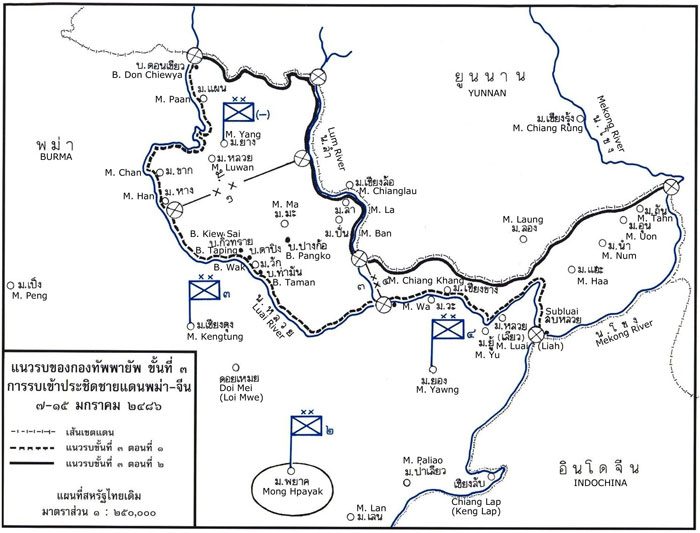
I started with Wikimedia's map of the annexed area as a guide, supplemented by its text description of the border.[14] A map in the RTA History showing tactical positions around Kengtung on 7-15 December 1943 also located names of significant towns in and around Saharat Thai Doem:[15] | Readers are encouraged to copy this webpage for their own future reference. See How to Copy Webpages. These pages were composed to be viewed best with Google Chrome. Revision list. See bottom of Text column on this page. Bibliography supports notes. Unless otherwise noted, Thai-English translations are by Wiyada Kantarod. 2.^ Interview on Saturday, 01 April 2023 with Photo of Feuay by author: IMG_20230401_160901.jpg [\02370 Kengtung\Feuay.jpg]. 3.^ Location map from Wikipedia: Uttaradit. 3a.^ The following six bulleted paragraphs are a minimal summary of events relevant to Feuay. Reader should consult such Wikipedia articles as: Saharat Thai Doem, Phayap Army, Thai offensive into China, for more detail. 4.^ Wikimedia: Saharat Thai Doem. 5.^ Edward Young, Aerial Nationalism (Washington: Smithsonian, 1995), 182.
6.^ Wikipedia: Saharat Thai Doem History.
7.^ Young, ibid, 190.
8.^ Stowe, Judith A, Siam becomes Thailand (Honolulu: Univ of HI Press, 1991), 240.
9.^ ประวัติศาสตร์การสงครามของไทย 10.^ Young, ibid, 197. 11.^ Ibid.
11a.^ Unless otherwise noted, the source for the next eight paragraphs is Feuay.
12.^ RTA History, 151: the replacement bridge in the area of Mong Lin on Road Project 1.
13.^ RTA History, 195: an engineering unit working at Mong Hpayak, possibly on Road Project 1.
13a.^ Axis History Forum. Wisarut Bholsithi in "Thailand in WWII photos" on 21 Jun 2004.
13b.^ RTA History, pp 197-200.
14.^ Wikimedia: Saharat Thai Doem.
15.^ RTA History, 175, with markup (translations) inserted by author using Microsoft Publisher.
|
|||||||||||||||||||||||||||||||||||||||||||||||||||||||||||||||||||||||||||||||||||||||||||||||||||||||||||||||||||||||||||||||||||||||||||||||||||||||||||||||||||||||||||||||||||
|
|
||||||||||||||||||||||||||||||||||||||||||||||||||||||||||||||||||||||||||||||||||||||||||||||||||||||||||||||||||||||||||||||||||||||||||||||||||||||||||||||||||||||||||||||||||||
|
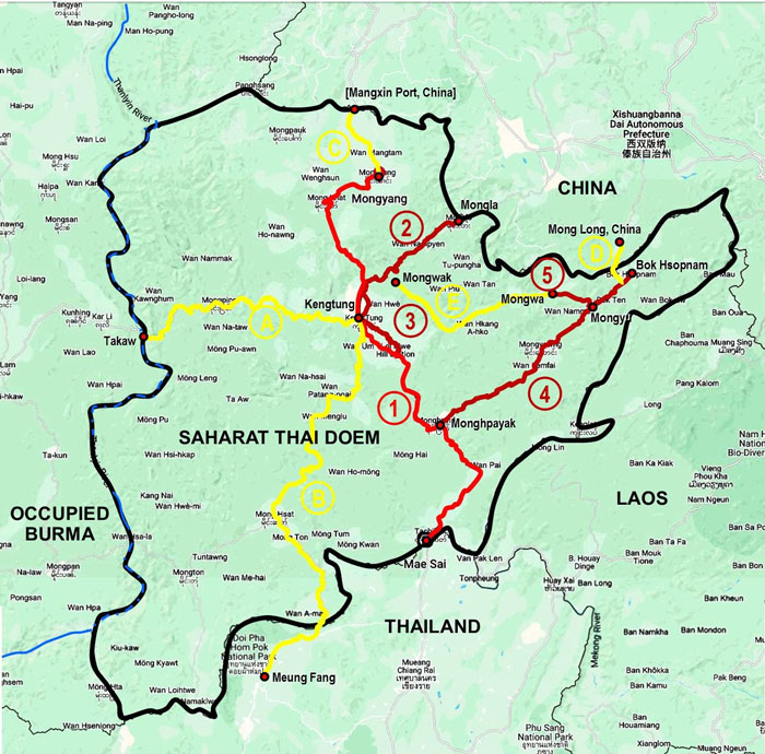
Tables of Roads Project[17] Those locations not found on any available map are marked with an asterisk in the tables below. Some modern day "English equivalent" names diverge from simple transliteration, but are believed to be currently correct. Note that minor differences in spelling of place names may inadvertently appear on the map and in the list below. First priority roads are numbered, 1 through 5, and marked in red or dark red on the map; while second priority roads are designated A through E and marked in yellow. First priority routes Project Road 1: Mae Sai to Mongyang (271 km)[18]
Project Road 2: Ban Nong Kang to Mong Chiang-lau (68 km)
Project Road 3: Kengtung to Bang Mao (40 km)[21]
Project Road 4: Mong Hpayak to Ban Hsopham (121 km)[23]
Project Road 5: Mongyu to Mongwa (24 km)
The RTA History noted that priorities were established for completing these roads, with an overall deadline of May 1943, just five months after the order was given --- which was wholly unrealistic. Further, five additional projects in Saharat Thai Doem were listed, should the army have completed the list above with time and resources left. Four of the five were apparently to connect to towns in the cardinal directions on the perimeter of Saharat Thai Doem, listed here clockwise from North, with the fifth totally internal to the territory: Second priority routes (colored yellow on the map):[27]
And yet more scope, this inside Thailand proper, was added as future projects (but not mapped here since the scope is not in Saharat):[29]
Allied attacks on the Kengtung area[30]
Afterwords A 1948 guidebook to Burma Roads:[32] gives compliments to Thai efforts on two roads in the now former Saharat Thai Doem: First, describing the road from Mae Sai to Kengtung:
Second, contrasting the road condition on a section upgraded by Thai forces vs the road that it connects to in China (emphasis added):
Of interest also is an estimate of practical speed limitations on the Mai Sai-Kengtung Road:
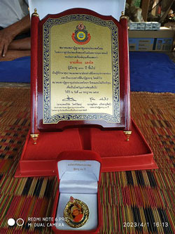
This gives some insight into the travel time for activities relying on the road, Mae Sai to Kengtung: the supply system by land for Thai forces in Kengtung, plus IJA preparations for the invasion of India (Imphal and Kohima) would have benefited from Thai improvements: 159 km from Mae Sai to Kengtung at 10 mph (16 kph) would have taken about 10 hours. However, Thailand's invasion of the Shan States using this road and others to Kengtung, would have had a much slower average speed --- and thus have taken a longer time to traverse. Feuay Dtang-rid today at 105 Feyay has been awarded a plaque by the Thai government basically for his longevity:[36]
In translation, it reads approximately:
Williams-Hunt Collection The selection of aerial photos doesn't extend nearly far enough beyond Kengtung to view the various road projects ordered by Phibun.
|
16.^ Google Maps of Saharat Thai Doem area, annotated by author using Microsoft Publisher 17.^ Tables based on RTA History text, 196. All distances in parentheses are from RTA History. All coordinates are for locations found on Google Earth, unless otherwise noted. 18.^ Road Project 1 follows present day Burma Route 4 from Mai Sai, Thailand to Kengtung; the road north from there to Mongyang carries no Burma Route number.
19.^ The road northeast to Mong Chiang-lau splits off the Kengtung-Mongyang Road at Ban Nong Kang which is defined as being 17 km north of Kengtung (it is not shown on any map).
20.^ Mong Chiang-lau is presumably opposite Mongla across the Lum River in China.
21.^ The description in RTA History plus that in The Motor Roads of Burma suggests this route goes through Loi Mwe. Doi in Thai and Loi in Burmese both mean mountain, and Mei may be the Thai rendering of the Burmese Mwe. 22.^ Pang Mao not found, but assumed to be at intersection of unnamed road heading south from Loi Mwe and intersecting Burma Route 4 at coordinates shown. 23.^ The road going north-easterly from Mong Hpayak follows Burma Route 49 as far as Mongyawng, where the route designation ends.
24.^ This town was misspelled in the RTA listing as เนืองยู้; ie, with a น instead of a ม. 25.^ An alternate spelling used on the tactical map is เชียงขาง; ie, with an า in place of an อ. 26.^ Wan Ha is the only town in the immediate area and is almost exactly the specified 24 km from Mongyu.
27.^ The descriptions of second priority roads do not include intermediate locations; thus, each listing is just origin-destination. The map symbols column shows the original order of the roads as listed in RTA History. They are here reordered in the cardinal directions from north clockwise. 28.^ The description reads, in translation, "Extend old road in Mongyu, ยู้, to north border". However, the "north border" isn't readily accessible from Mongyu. More likely the intended starting point was the north end of Project Road 1; ie, Mongyang, ยาง, and that is what is tracked on the map. 29.^ RTA History, 195.
30.^ Extracts from
31.^ Following three items are extracts from:
32.^ The Motor Roads of Burma (Fourth Edition) (Rangoon: The Burmah Oil Co, (Burma Trading) Ltd, 1948)
33.^ Ibid, 64. This describes part of Phibun's Project Road 1. "Metalled" road here probably means "stone chips mixed with tar to form a road-surfacing material tarmac". (Wikipedia: Road Surface, Gravel surface)
34.^ Ibid, 65. This contrasts Phibun's Project Road 4 with China's connecting road at that time. While the border is actually at least another 37 miles (60 km) beyond Mongyaung, the descriptions of road quality are probably accurate. 35.^ Ibid, 66.
36.^ Photo of plaque by author:
|
|||||||||||||||||||||||||||||||||||||||||||||||||||||||||||||||||||||||||||||||||||||||||||||||||||||||||||||||||||||||||||||||||||||||||||||||||||||||||||||||||||||||||||||||||||
 While tracking two B-24 crash sites around Uttaradit in 2022,
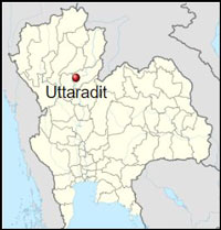 On the first of April, 2023, we revisited Feuay Dtang-rid at his house in Uttaradit for an entertaining two hours: He met us with a spritely gait and entered into a long, lucid discussion;
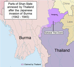 On 08 December 1941, the IJA entered Thailand by land from Cambodia and by sea. After some initial resistance by the RTA and the Royal Thai Air Force (RTAF), and subsequent dispute within the Thai Parliament, the Thai government leader, Field Marshall Phibun, signed a "Pact of Alliance" with Japan on 21 December 1941. A secret portion emphasized Thailand's immediate assistance to Japan's war effort, [particularly allowing access to Burma] in exchange for Japan's assurance that it would return to Thailand its "lost territories" in Shan State, [as shown in purple on the map as Saharat Thai Doem
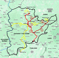 With this in mind, Phibun ordered the construction / improvement of 524 km of roads in the newly acquired territory to be completed in five months, ie, by the end of May 1943.
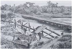 At the Nampong River, one or more of the twenty-man groups built a bridge about 100 meters in length to span the river, using raw, unfinished teakwood; it might have been similar to the one shown here,
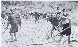 The road was new --- constructed, not improved, following simple paths close to the river, sticking to the river plain, avoiding traversing heights. Equipment was primarily manual; eg, "Thai hoes", as shown in this photo.