Japan in Northwest Thailand during World War II
| Aerial Photomosaics based on Geo-spatial Digital Archive Project The Williams-Hunt (W-H) Aerial Photograph Digital Collection |
| Text | Notes | |||||||||||||||
|
This page discusses the assembly of photomosaics from World War II aerial photos taken by the Royal Air Force (RAF)[1] and provided on-line by the Geo‑spatial Digital Archive Project (GDAP) in its Williams-Hunt Aerial Photograph Digital Collection.[2] The source of these photos has asked that the following information be included regarding the aerial imagery treated below:
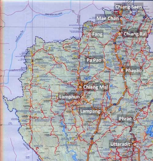
In northwest Thailand, the following areas are covered by the GDAP website: Actually, this extends beyond northwest Thailand proper, but since I have already assembled photomosaics for these locations, I have included them. The full geographic range of coverage of the collection can be seen at the GDAP's Williams-Hunt Aerial Photograph Digital Collection Location webpage. The photomosaics were initially put together manually in 2009, using in each case, a Google Earth view of the area as a backdrop to ease alignment and lessen "creeping" errors. Col Surat Lertlum, Program Head, Computer Science Program at Chulachomklao Royal Military Academy, cautioned:[5] If you do not use RS image processing or GIS software to geo-reference each image first before creating the mosaic, the result will accumulate error and distortion from each photo, and finally it will be more difficult to geo-reference your mosaic to a map. In 2012, the photomosaics were redone using Microsoft ICE (Image Composition Editor). That program is not an answer to Col Lertlum's comment above; and care must still be used in applying the program. But it does make the process of assembling, or "stitching" the individual photos together immensely easier, in some cases. Some suggestions about its use, though: Brightness and contrast in Williams-Hunt photos should be enhanced before assembling them --- it makes it easier to proof ICE solutions; or to assemble them manually. First, put the images together manually in a program such as Microsoft Publisher or Adobe PhotoShop. Not often, but occasionally, ICE will go wildly astray, and the rough-in will provide a control. The titles of the images must be in a numerical or alphabetical order: it would appear that ICE uses that order in assembling the images. ICE recognizes margins of photos and automatically deletes them from its processing; ie, no cropping is necessary. If an image is out-of-place, remove it from the set sent to ICE. Reprocess the smaller set. Then send the resulting stitched up image plus the errant image together into ICE for processing. If the particular image still is not properly located, insert it manually using Publisher or PhotoShop. If the mosaic has more than one row or column of images, process one row or column of images at a time. Then join the resulting stitched up products from ICE. ICE photomosaics seem to be of slightly lower resolution than the individual photos. No provision is available in ICE for designating ground control points, which is Colonel Lertlum's concern: hence, the mosaics may not accurately represent what is "on the ground". Minor errors in one photo will be passed to adjacent photos. Further, Williams-Hunt photos are the product of a technology 70 years ago --- aerial and now satellite photo equipment are orders of magnitude better ; in addition, the negatives or photo-positives from which the Williams-Hunt collection has been digitized may have shrunk or expanded irregularly over the years (dimensional stability is an unknown variable).[6] The locations in northwest Thailand covered by the Williams-Hunt collection are: Chiang Mai
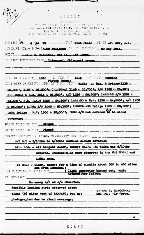
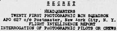
This may appear confusing because I don't yet have a specific example of an aerial photo flight report describing an actual photo in hand. But I include it to properly record how to interpret some of the information provided on some aerial photos. The abbreviation, "PR" or "PRS", in the handwritten annotation on an aerial photo is an abbreviation forPhotographic Reconnaissance / Squadron, an organizational unit in the US Army Air Force (USAAF). It will typically be preceded by a number identifying the particular squadron; eg, 9, 35, 40, etc. The photos for the first aerial mosaic (undated) presented for Lampang (here) have these identifiers in the upper left corners:[7]
This corresponds to "5 M 135" seen in the annotations illustrated above; ie, that was the mission number on which the photos were snapped. As a result, unfortunately, without matching mission reports, USAAF aerials are otherwise unidentifiable.
Unfortunately I have not yet found RAF reports on its aerial photo flights equivalent to those that have come to light in US archives.[9] However annotations on its aerial photos at least include dates. Typical example:
In the current economic situation, the process of cataloging, duplicating, and making additional aerial photos available seems to have been short-funded as non-critical by both the UK and the US governments.
|
See Key for interpreting page content. Revision list. See bottom of Text column on this page. Bibliography supports notes. 1.^ For USAAF records, 2.^ The collection and its origin are described in detail in: Lertlum, PhD, Col Surat, and Dr Elizabeth Moore, Williams-Hunt Aerial Photograph Collection, (undated); available as here linked. Moore, Elizabeth, The Williams-Hunt Collection, Sari - International Journal of the Malay World and Civilisation, 27(2)(2009), pp 265-284. Periasamy, Makeswary, "A View from the Top", biblioasia, 5(1) (Apr 2009), pp 38-42. 3. deleted. 4.^A "Terrain" map from Nations Online Project: Searchable Map and Satellite View of Thailand using Google Earth Data. Annotation by author using Microsoft Publisher.
5.^.
Email
6.^ To do item: redo the photomosaics, creating geotiffs with Quantum GIS Lisboa and then joining them using US Army Corps of Engineers' HyperCube or Racur's PhotoMod.
Combat Squadrons of the Air Force World War II, 40th Photographic Reconnaissance (p 188).
7a.^ 21st Photo Squadron aerial photo flight report of 29 May 1944 (USAF archive microfilm reel A0878, p 10). 21st Photographic Reconnaissance Squadron(History and Lineage). Combat Squadrons of the Air Force World War II, 21st Photographic Reconnaissance (p 169).
8.^ ibid, heading extracted.
9.^ See webpage: Aerial Photographic Intelligence from US Government Records. 10.^ Extract from 02538.jpg (RAF-LPG-2538-ID.jpg).
Long-term to-do items Add list of Williams-Hunt photos used in assembling photomosaics presented here. Assemble remaining (vertical) aerial photography of Thailand in Williams-Hunt Collection.
|
|||||||||||||||