Japan in Northwest Thailand during World War II
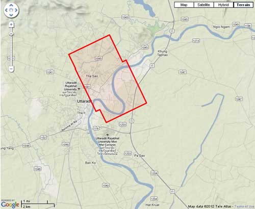
| N17°37.60 E100°05.80[1] | Uttaradit (Th: อุตรดิตถ์ / Jp: ウッタラディット ) Williams-Hunt (W-H) Aerial Photomosaics Page 1 of 1 |
Route 0011 |
| Text | Notes | |||||||||
|
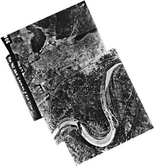
This page discusses World War II aerial photos taken by the Royal Air Force (RAF) and provided on-line by the Geo-spatial Digital Archive Project (GDAP) in its Williams-Hunt Aerial Photograph Digital Collection.[2a]
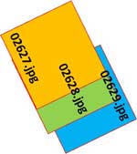
The three-photo aerial photomosaic:[4]
A higher resolution image is available for download here. The following GDAP images were used in the above photomosaic:[5] and assembled approximately like this, using manual fitting:[6]
|
See Key for interpreting page content. Revision list. See bottom of Text column on this page. Bibliography supports notes. 1.^ Source: Google Earth fix on apparent center of town. 2.^ Stationing needed. 2a.^ The collection and its origin are described in detail in: Lertlum, PhD, Col Surat, and Dr Elizabeth Moore, Williams-Hunt Aerial Photograph Collection, (undated); available as here linked. Moore, Elizabeth, The Williams-Hunt Collection, Sari - International Journal of the Malay World and Civilisation, 27(2)(2009), pp 265-284. Periasamy, Makeswary, "A View from the Top", biblioasia, 5(1) (Apr 2009), pp 38-42. 3.^ "Terrain" map from Nations Online Project: Searchable Map and Satellite View of Thailand using Google Earth Data. Annotation (red & blue colored items) were placed by author using Microsoft Publisher. 4.^ Photos 02571.jpg and 02572.jpg were assembled using Microsoft ICE (Image Composition Editor). Because of a peculiar distortion when ICE was used on all four images, photos 02498.jpg and 02573.jpg were fitted manually. Mosaic is so oriented that its north is to the top of the page.
5.^ The files used here are 1024 KB. Downloading the files which are designated "[full size]" requires a special request form to be emailed to the Head, GDAP. 6.^ Drawn by author with Microsoft Publisher.
|
|||||||||