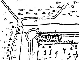
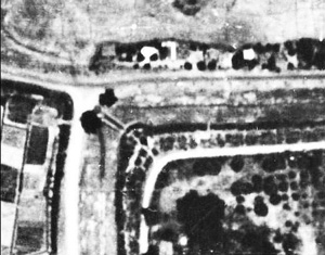
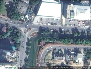
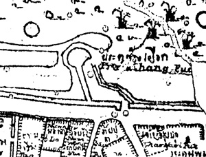
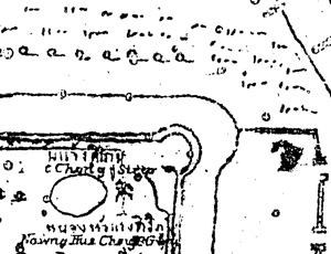
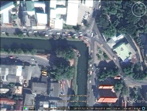
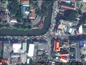
| N18°47.30 E98°59.14 |
Working Paper Old Chiang Mai City Walls Page 2 of 3 |
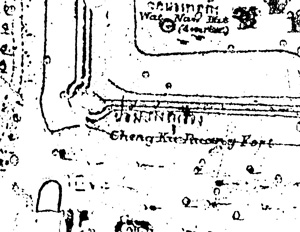
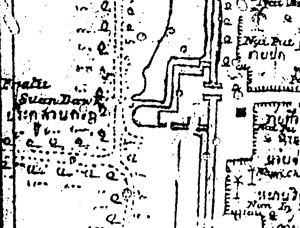
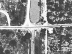
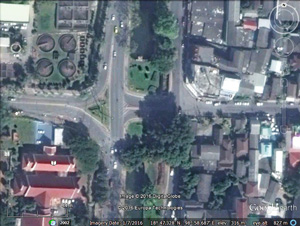
Route (NA) |
| Text | Notes |
|
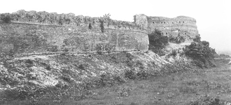
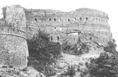
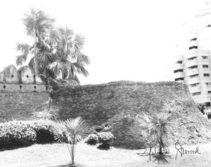
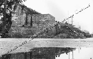
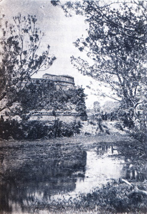
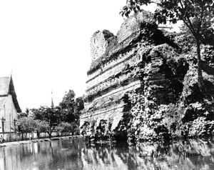
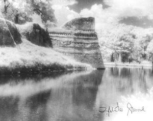
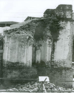
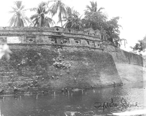
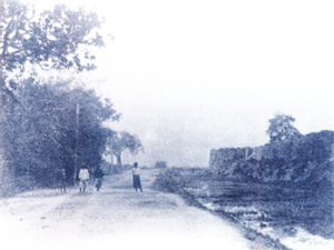
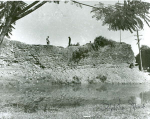
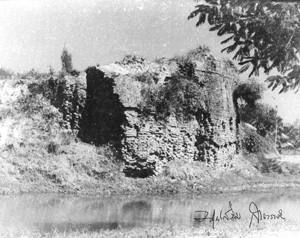
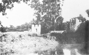
1893: 1944: 2016: Date uncertain, but before 1941, looking WSWerly:[5]
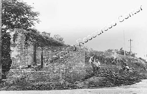
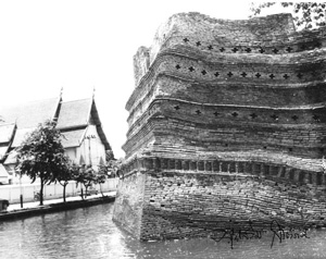
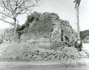
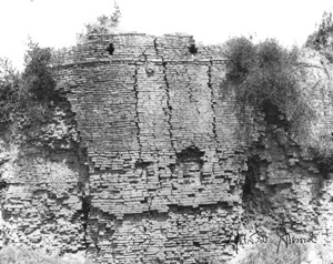
Close up of the bastion proper:[6]
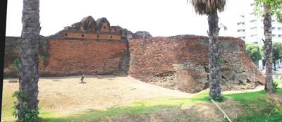
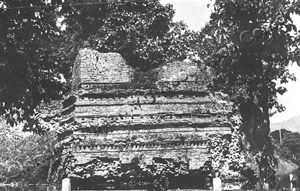
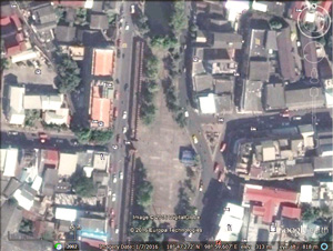
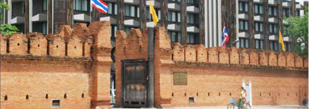
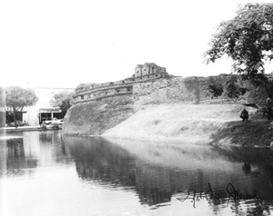
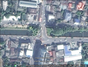
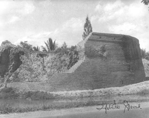
Current view, looking SWerly:[7]
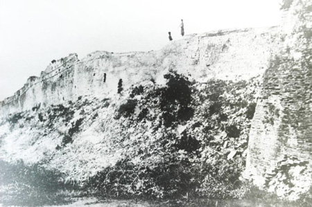
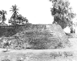
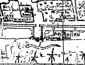
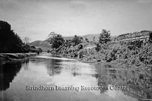
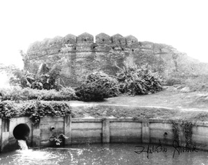
Date uncertain, perhaps 1895, looking ESEerly:[8]
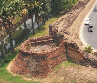
A current view for comparison is obscured by trees. This is a photo looking down from the Tokyo Vendor Hotel in a ENEerly direction:[9]
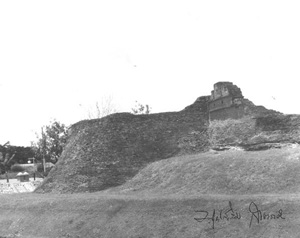
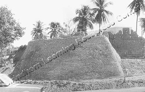
Other views: CMU Historical Photo Collection No. 476: Chaeng Hua Lin city fortress with the Chiang Mai Ram Hospital on the right, 1998:
CMU Historical Photo Collection No. 475: Chaeng Hua Lin city fortress, 1998:
CMU Historical Photo Collection No. 474: Chaeng Hua Lin after the renovation by the Department of Fine Art's renovation: Payap Collection No P0413: looking SEerly at bastion, 1988:
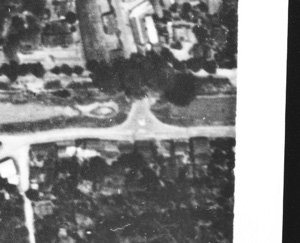
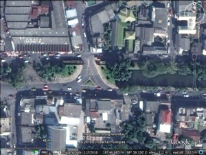
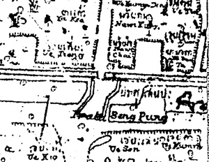
M2. Chang Puak Gate: N18°47.727 E98°59.202 1893: 1944: 2016: Date uncertain, looking SEerly at Chang Puak Gate:[10]
Note that the "gate" was merely ceremonial by this time: a mere portal, with no "door(s)" to secure the opening. To clarify, the walls in the photo above appear in outline below, with a wide unsecurable opening:
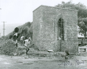
Payap Collection No P0390: Under restoration in 1967:
Other views of restoration: CMU Historical Photo Collection No. 471. The renovation of Chang Phueak Gate, the stone inscription can be seen inside, 1967:
Payap Collection No. P0389: [Looking easterly along the inside of the city wall at] Chiang Mai City workers restoring Chang Puak Gate in 1964. [Note trees lining moat outside the wall] [photographer: Boonserm Satrabhaya]:
Payap Collection No. P0417: [Looking east along the inside of the city wall at] Chiang Mai City workers restoring Chang Puak Gate in 1967. [Note trees lining moat outside the wall] [photographer: Boonserm Satrabhaya]:
1893: 1944: Not available 2016: National Archives of Thailand: A Chiang Mai Rampart, c 1906:[12]
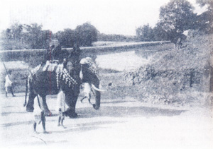
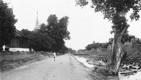
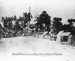
Tanaka post card (after 1911), no caption: looking south on Chaiyapoom with Wat Sri Phum on the left and Sri Phum corner on the right (out of the field of view):[13]
CMU Historical Photo Collection No. 477. City Fortress and walls at the Chaeng Sri Phum City Corner before the renovation. The temple in the photo is Wat Chai Si Phum or Wat Phan Ta Koen, 1967:
Payap Collection No. P0416. Chaeng Sri Phum corner: "Sri Phum Corner" [NE corner of old Chiang Mai] in 1967 before it was renovated by the Fine Arts Department 4 [photographer: Boonserm Satrabhaya]:
CMU Historical Photo Collection No. 478. The city fortress and wall at the Chaeng Sri Phum city corner after the renovation and its second collapse in 1973 (the unusual tones, especially the very pale leaves on trees are characteristic of infra-red film that Boonserm used occasionally): CMU Historical Photo Collection No. 479. The city fortress at Chaeng Sri Phum, 1998:
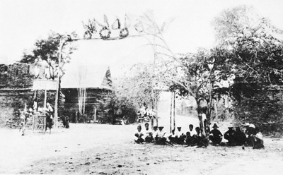
1893: 1944: 2016: Payap Collection No. P0086. Tha Pae Gate during the reign of Rama V [r1868-1910]. [Walls are not visible. Gate seems to be in center of photo as a simple wooden entrance frame: what is here would be of symbolic value only, without any security function.]
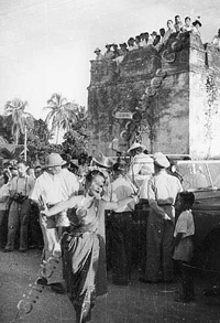
Payap Collection No. P0321: Traditional dancers leading a Songkran parade past Tha Pae Gate in 1950; some of the crowd mounted the Tha Pae city wall for a unobstructed view [photographer: Boonserm Satrabhaya] [The site of the future Montri Hotel is behind the camera]:
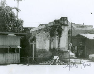
CMU Historical Photo Collection No. 457: the Tha Pae Gate collapsed due to a storm. A stone inscription can be seen inside, no date [photographer: Boonserm Satrabhaya]:
CMU Historical Photo Collection No. 458: the Tha Pae Gate collapsed due to a storm. A stone inscription can be seen inside, no date [photographer: Boonserm Satrabhaya]:
Current view:
1893: 1944: 2016: CMU Historical Photo Collection No. 480. Chaeng Khatam city corner, 1973:
CMU Historical Photo Collection No. 481. Chaeng Khatam city corner, 1998:
1893: 1944: 2016: There seem to be no historic photos of Chiang Mai Gate; but see discussion about Payap Collection No. P0069 in UNKNOWNS on page 3. See also comment about Suan Prung Gate below.
1893: 1944: 2016: Payap University Archives: Chang Lo Road along the southern moat of Chiang Mai, c 1927. Note the apparent bastion at the end of the wall which would imply photo was taken from near Suan Prung Gate, looking west towards Ku Hueang (SW) Corner:[13]
Payap Collection No. P0070. City wall around Suan Prung Gate; undated. [The gate is assumed to be in the distance. Photo was taken from the moat, probably at the crossing at Chiang Mai Gate (Doi Suthep is in background).]:
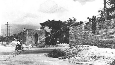
CMU Historical Photo Collection No. 469. Suan Prung Gate before the renovation by the Chiang Mai City Municipality, 1967:
CMU Historical Photo Collection No. 468. Suan Prung Gate before the renovation by the Chiang Mai City Municipality, 1967:
See also discussion about P0069 in UNKNOWNS on page 3. The original layout of the old city wall as implemented by King Mangrai around 1296 is said to have placed one gate on each of the four walls. Tradition has it that the Suan Prung Gate was established more than 100 years later during the reign of King Sam Fang Kaen: his mother who lived outside the southwest corner of the city was overseeing construction of Wat Chedi Luang within the city and he wanted to shorten her travel each day. The story may be valid; however, it should be noted that the gates on the other three sides are located in the middles of their respective walls. Uniquely, the gate on the south wall, the first gate there, the Chiang Mai Gate, was located far from the middle of the south city wall. Access to the road to Lamphun is used in hindsight as justification for this off centered location. A difficulty with this explanation is that to access the road which is on the far (east) river bank, a traveler would have had to cross the river and tradition locates early bridges across the Ping farther north, near the current pedestrian bridge at the Ton Lam Yai Market. Which is to say that a traveler going to Lamphun would have gone out the east gate (today's Tha Pae Gate) to get to the bridge(s). He would not have gone out the city's south gate. A simpler explanation may lie in a major function of the gate: that to provide access to the Hai Ya crematory south of the city. As such, the gate was viewed by Thais of that era as an object possibly to be feared, a "spirit" gate. The laws of symmetry may have dedicated locating a southern gate for normal use so as to provide an architecturally balance to Suan Prung Gate, ie, the Chiang Mai Gate.
1893: 1944: 2016: CMU Historical Photo Collection No. 482. Suan Prung Gate before the renovation by the Chiang Mai City Municipality, 1967:
CMU Historical Photo Collection No. 486. The city wall fortress at Chaeng Ku Hueang, the first one before the later renovation and restoration:
CMU Historical Photo Collection No. 484. The city wall fortress at Chaeng Ku Hueang, the first one before the later renovation and restoration:
CMU Historical Photo Collection No. 483. Chaeng Ku Hueang, 1998:
1893: 1944: 2016: Payap Collection P0097. Suan Dok Gate. Also in Boonserm, Chiang Mai: Then and Now, p 38 (photo here from latter source):
|
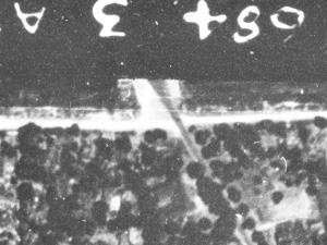
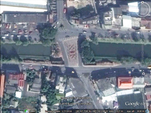
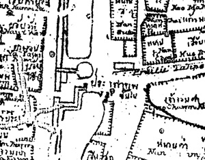
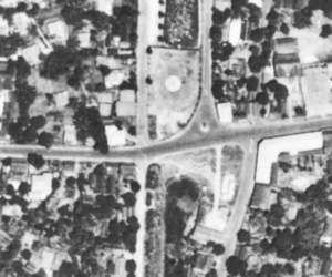
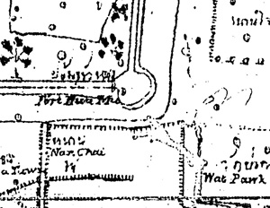
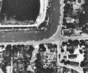
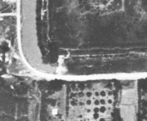
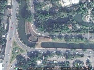
4.^ Each numbered item, M1, M2, etc, begins with three dated entries, excerpted from the same three sources: 1893: Inthawichayanon, Map of Chiang Mai, 1893 1944: Williams-Hunt Aerial Photos Collection 2016: Google Earth. Note that there are inconsistencies in scale amongst these selections. North is up-page for Inthawichayanon and Google Earth images. Williams-Hunt images should be rotated 5° clockwise to bring north page-up. Most images have been enhanced using IrfanView. Microsoft Publisher was used for all annotations. All location coordinates are derived from Google Earth.
5.^ Photo by Tanaka in postcard format, date unknown; copy provided by Oliver Backhouse. Payap Collection No. P0102, undated.
6.^ Ibid, excerpted.
7.^ DSCF3036 and 7, 08 Apr 2016, stitched into panorama with Microsoft ICE.
8.^ Payap Collection No. P0095, City wall at "Hua Rin Corner", undated. Teakdoor displays photo with caption "Chiang Mai's old city walls, as viewed in 1895".
9.^ DSCF3067, 08 Apr 2016, extracted.
10.^ Boonserm, Chiang Mai Then and Now, p 40.
11.^ Payap University Archives, per Ongsakul, Sarassawadee, History of Lanna, translated by Chitraporn Tanratanakul (Bangkok: Silkworm Books, 2001), p 70. While the photo doesn't show the gate itself, it does present the immediate surroundings.
12.^ National Archives of Thailand, per Ongsakul, Sarassawadee, ibid, p 81.
13.^ Tanaka as source is confirmed by postcard back of photo. The photo is undated; however Tanaka arrived in Chiang Mai in 1911, hence the "after 1911" date. Photo provided by Oliver Backhouse, grandson of Evelyn van Millingen, Forest Manager for Bombay Burmah Trading Co in northern Thailand in the late 1930s through the evacuation in late 1941. Added 14 Apr 2016.
13.^Payap University Archives, per Ongsakul, Sarassawadee, ibid, p 207. |