Japan in Northwest Thailand during World War II
| N18°47.30 E98°59.14[1] |
Working Paper[1a] Old Chiang Mai City Walls page 1 of 3 |
Route (NA) |
| Text | Notes |
|
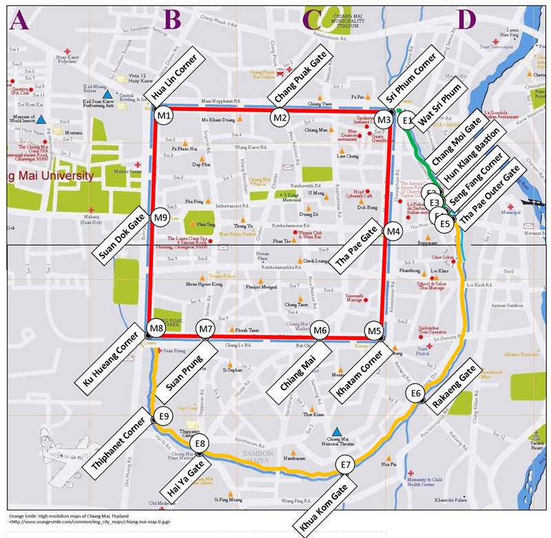
The walls were composed of two distinct perimeters as recorded in the Inthawichayanon Map of Chiang Mai, dated 1893. That map, plus various photographs, aerial and on-ground, comprise primary evidence. At the present time, the more visible of the two perimeters is the approximate 1.5 km square comprising the "old city", once a continuous wall penetrated by gates with bastions at its corners. Today the wall is largely gone; however its bounds are traced by moats which continue to surround that area plus corner structures with various amounts of restoration and gate structures which are only approximate reconstructions. That city wall is shown in red on the following map with corners and gates numbered sequentially starting with M1 at Hua Lin Corner on the city's northwest corner and moving clockwise to M9, the Suan Dok Gate, on the west wall. The less visible perimeter is itself composed of two distinct structures, both of which lie outside once built-up city wall. An earthen structure extends from the southwest corner of the city wall to the "Outer Tha Pae" Gate to the east of the Tha Pae Gate. It is traced in orange on the map below. From the "Outer Tha Pae" Gate to the northeast corner of the city wall, a built-up wall existed and is shown in green below. Features in these two barrier walls are numbered sequentially from E1 at Wat Sri Phum through to E9 at Thiphanet: |
Additional information is provided in this column for the convenience of the reader. Please advise author of any errors. Readers are encouraged to copy this webpage for their own future reference. See How to Copy Webpages. These pages were composed to be viewed best with Google Chrome. Revision list. See bottom of Text column on this page. Bibliography supports notes. 1.^ Google Earth fix on approximate center of old Chiang Mai. 1a.^ Off topic item published for information. 2.^ Forbes, Andrew and David Henley, The Fortifications of Chiang Mai and the Enigma of the Finlayson Map, Informal Northern Thai Group, 13 Jul 2010. 3.^ Inthawichayanon, Map of Chiang Mai, 1893 |
|
|
|
|