Japan in Northwest Thailand during World War II
| N18°02.53 E99°54.96 [1] |
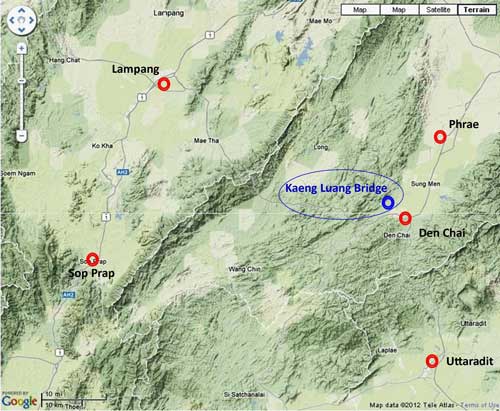
Kaeng Luang[1a] Bridge (Th: สะพานแก่งหลวง / Jp: ケンルン橋 ) Phrae Province Page 1 of 2 |
RR Bridge Northern Route Sta 551.553 [2] |
| Text | Notes | ||||||||||||||||||||||||||||
|
This page 1 reviews attacks on the bridge, while page 2 examines the shootdown of the B-24 on 21 November 1944.
Attacks on the Kaeng Luang Bridge
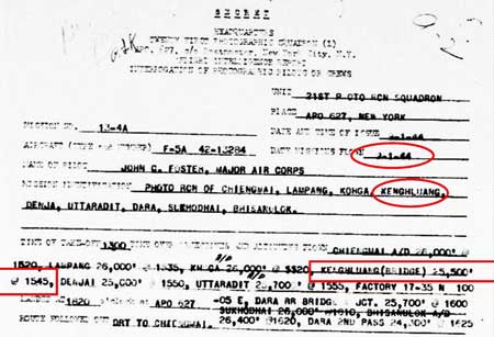
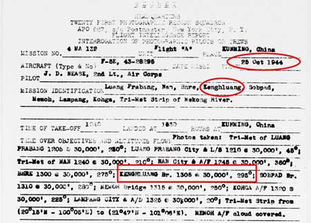
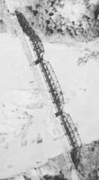
The bridge was recorded as having been photographed on this date from 25,500 feet:
The first attack on the bridge was recorded in the general event list in USAAF Chronology (Chrono) as occurring on 24 April 1944: CBI - THEATER OF OPERATIONS - CHINA (14AF): In Thailand, B-25s damage bridges near Dara and Kengluang and strafe a factory at Dhasan. P-40s on a diversionary strike strafe numerous targets of opportunity at Kengtung, Burma. B-25s on a sea sweep hit 2 small steamers off Cape Bastion, China with cannon fire, claiming 1 vessel sunk and the other left burning. The heading for this Chrono paragraph includes "14AF", or 14th Air Force, headquartered in China; the use of B-25 bombers, "Mitchells", tends to confirm that the tasks were those of the 14th, which relied almost exclusively on them --- the other Allied major air unit operating in the area, the 10th Air Force, primarily flew B-24 bombers, "Liberators". The location of Dhasan is unknown. It is unclear if the "diversionary strike" was intended to relate to the bombings in Thailand. USAAF 341st Bomb Group and its unit records were able to provide a wealth of detail about the attack on the Kaeng Luang bridge, hidden by the bland Chrono summary above:[3α]
Not shown here, but the target was incorrectly identified as Xenglaung Bridge in both the 341st BG and 69th Comp Wing summaries. That spelling suggests a Chinese, rather than a Thai, place name (there is no location in China with a name resembling Xengluang). See below for discussion.
Less than a month later, the USAAF Chrono recorded another attack on the bridge: CBI - THEATER OF OPERATIONS - CHINA (14AF): B-25s strike Kengluang bridge, Siam and hit installations near Wan Pa-Hsa, Burma. P-40s strafe troops near Pingkai, Burma, and along Mamien Pass and in the Mengta area of China. 92nd Fighter Squadron, 81st Fighter Group, moves from Karachi, India to Kwanghan, China with P‑47s; first mission is 1 Jun. And 341st BG unit records provided more detail: the attack this date was assigned to the 22nd Bombardment Squadron, Mission B-235:[3å] 15 May 44 – Six B-25s of 22nd BS Mission B-235 departed Yangkai at 0834 hours to attack the Kenghluang Railroad Bridge (Thailand), led by Capt Miller. There was some damage scored on the north approach, but it was hardly a memorable mission. This bridge has proved to be a somewhat difficult target due to being set low in a gorge with high surrounding hills.
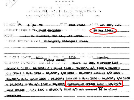
The bridge was photographed on this date from 28,800 feet:
The USAAF Chrono claimed the bridge as a "knock out" on this date: CBI - THEATER OF OPERATIONS - CHINA (14AF): 51 P-51s and P-40s pound shipping along the Yangtze River, claiming direct hits on 5 small ships; 16 P-51s and P-40s bomb Kweiyi and Yoyang and installations on the river to the S; 10 P-38s bomb the bridge and warehouse area at Nanchang; 12 P-40s bomb Pingkiang; 4 B-25s bomb Hankow airfield, Pailochi, and motor convoy at Yoyang; 6 other B-25s knock out the bridge at Kengluang; 13 B-24s pound the town of Lungling, causing big fires, while 14 B-24s, supported by P-40s blast the warehouse area at Lashio, Burma; 4 P-40s destroy several aircraft during strafing runs on Linfen and Hohsien Airfields. In addition to alternate spellings for the bridge location as noted above (eg, Xengluang), the report quoted directly above illustrates another problem common in tracing action in Thailand: a mission report often groups the typically few targets in Thailand (here one) with the many elsewhere (here China) leaving the impression that all targets were in China; the notable exception is Lashio which is specifically identified as in Burma "Lashio, Burma". This last treatment would imply that, if "Kengluang" were not in China, it would have been called out in similar style; ie, "Kengluang, Thailand". But not so. Note also, the occasional misspelling as Xengluang, starting with an X, suggests a Chinese place name, which would fit in nicely with the other place names in China in this grouping. Hammel identified the unit attacking Kaeng Luang as the 341st Medium Bombardment Group.[3b] 341st BG unit records provided the expected rich detail. The task was assigned to the 22nd Bombardment Squadron as Mission B-243:[3c] 31 May 44 – Six 22nd B-25s took off from Yangkai at 0913 hours to attack the Kenghluang Railroad Bridge, Thailand. Six planes attacked Kenghluang Bridge. Tracks were torn up for nearly 150 feet on the north approach, and on the south end also. There was one apparent hit on the center span, throwing up debris believed to be tracks, ties and part of the superstructure. However, photographs show the bridge is still standing. Note: Crews reported a railroad tunnel located where the railroad running north makes a sharp turn to the west, about 18 miles north of the Kenghluang Bridge and 25 miles east of Lampang. The tunnel appears to be about 600 feet long and is believed by the crews to offer a good low-level target and probably easier to destroy than the Kenghluang Bridge. Several small bridges were also observed in the same region; one between the tunnel and the Kenghluang Bridge, and three or four west of the tunnel. The tunnel noted was the Huai Mae Lan tunnel, 130m long (RR sta 574+115). Actually, thirteen small (up to 40m long) bridges in total are included in railroad features in the 25km either side of the tunnel.[3d]
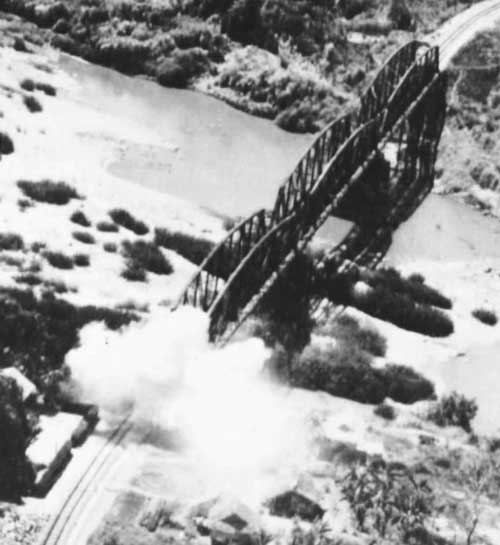
Typewritten caption: [Kaeng Luang] bridge in north Thailand, a connecting link on the strategic railroad supplying Japanese troops in Eastern Burma is knocked out by bombs from North American B-25 Mitchells of the US Army 14th Air Force --- the famous "Flying Tigers" of Maj Gen Claire L Chennault. Handwritten caption: Kenghlaung [sic] Bridge The information typewritten is plausible; however that handwritten is bogus (see Strotman caution about publicity photos). As noted above, the attack on the bridge on this date was assigned to the 22nd BS, while this handwritten note would credit the 491st (in boldface). The mission number 4MA188 fits neither 22nd nor 491st series. These errors must bring the validity of the date into question, though it is also plausible. In fact, the explosion on the south approach to the bridge, as caught by the camera (see enlargement below), might better be related to Lt Albert Toney's bombs which "hit just south of the bridge either on the bank or near the south approach" on 24 April 1944. Perhaps to state the obvious, the oblique view in the photo above is obviously not the product of a "recce" aircraft: they were unarmed and, for that reason, over hostile territory flew only at high altitude. The photo was likely taken from the tail of the B-25 that dropped the bomb. A closeup of the photo shows dust raised presumably by a bomb blast at the near (southerly) end of the bridge:[4b]
Between 01 and 19 June 1944 Apparently at some point following the above photo --- the undated photo below was taken, and can be seen to show a repaired southerly approachway:[5]
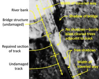
Damage from 31 May attack would seem to have been limited to the south approachway --- this closeup of that approach in the photo above shows fresh rail ballast and presumably new track in place: Japanese bridge repair crews were noted for their quick response, and the above photo documenting same probably motivated another attack on the bridge just a few weeks later, on 19 June 1944.
In short order, the USAAF Chrono recorded that the bridge was again hammered (note that this report could be read as locating the bridge in China): CBI - THEATER OF OPERATIONS - CHINA (14AF): In China, about 150 fighter-bombers and 8 B-25s again pound a variety of targets throughout the Tungting Lake area; targets include much shipping from Siangyin to Chuchou, and at various points along the Siang-Chiang River, villages and compounds between Yiyang and Changsha, and boats and river area at Anking; 18 P-40s damage 2 bridges and destroy about 20 fuel trucks at Yuncheng; on the Salween front 15 P-40s hit trucks and military installations; and 4 B-25s bomb Kengluang bridge. 341st BG unit records reveal a rather more complex story at the bridge. The job was assigned to the 22nd Bombardment Squadron as Mission B‑247:[5a1] 19 Jun 44 – Four 22nd B-25s took off from Yangkai at 0700 hours to attack the Kenghluang Railway Tunnel, Thailand --- All planes succeeded in reaching the Kenghluang Railway Tunnel, which was observed through breaks in the clouds. These breaks, however, were neither sufficiently large nor frequent enough to permit a bomb run. Several attempts were made, but the overcast was building up rapidly. Planes 43-3617 and 43-3958, after repeated attempts, finally located a break (in the clouds) and spotted an airfield having two runways crossing in an 'X' pattern. These two planes dropped all bombs on the airfield but results were completely obscured by the cloud overcast. Planes 43-3435 and 43-3880 became separated from the others due to the bad weather. They found a lucky break in the clouds over the Kenghluang Railway Bridge. An excellent bomb run was made and all ten bombs dropped on the bridge. Clouds obscured the result. There is no Kaeng Luang railway tunnel; it is assumed that Allied intel had assigned that name to the Huai Mae Lan tunnel, first noted on 31 May 1944. In the north of Thailand, there was only one "X" pattern airfield: Mae Mo, and the current rice paddy terrain at the former site still displays bomb craters. Ironically Allied reconnaissance never observed any aircraft there. No follow-up is currently available in the archives about the result of the "excellent bomb run" with "all ten bombs dropped on the bridge".
The bridge was photographed on this date from 26,000 feet:
The bridge was photographed on this date from 30,000 feet:
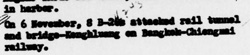
An Allied periodical, Brief of Principal Air Operations, reported: Transcription: On 6 November, 8 B-24s attacked rail tunnel and bridge-[Kaeng Luang] on Bangkok-[Chiang Mai] Railway. The rail tunnel is not identified; though, presumably, it would have been the Huai Mae Lan mentioned above, about 23km north of the bridge. The above report was probably used in preparing the following item which appeared in a later report from higher up the chain of command, the Road and Railroad Communications Report: Asiatic Area: Transcription: [Kaeng Luang Bridge A.58] This bridge was bombed by B‑24s on 06 Nov [1944], but no damage claimed. As noted above, B-24s were used by the 10th Air Force, stationed in India at this time.
The bridge was photographed on this date from 28,500 feet: Transcription: Bridge 5 miles W of [Den Chai] 28,500' @ 1255 @ 310° (possibly [Kaeng Luang] Bridge.
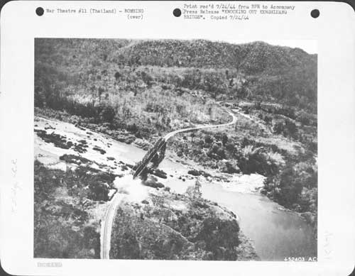
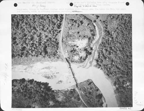
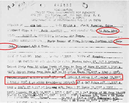
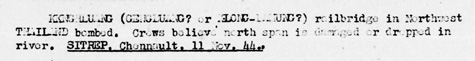
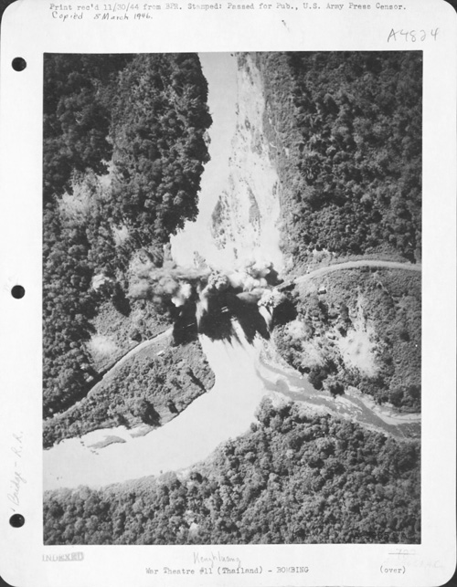
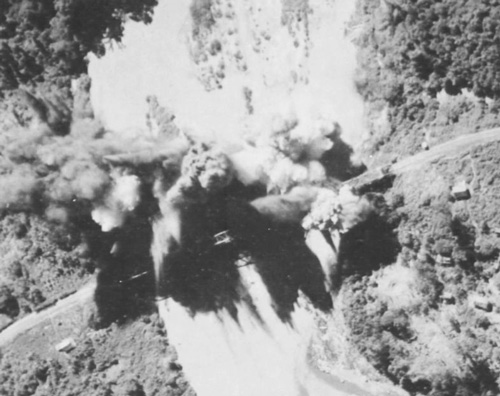
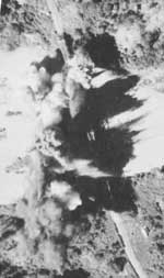
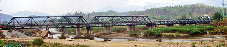
Transcription: [Kaeng Luang] rail bridge in northeast Thailand bombed. Crews believe north span is damaged or dropped in river. SITREP, Chennault, 11 Nov 44. "Chennault", ie, Maj Gen Claire Chennault, indicates the report came from the 14th Air Force, as did the bombers. Possibly in error, or possibly to emphasize success in disabling the bridge, the event was restated in the following biweekly report: Transcription: On 11 Nov, B-25s damaged [Kaeng Luang] bridge (35 miles SE of Lampang) and aircraft attacked other railway targets in the neighborhood of Ban Dara Bridge (this bridge having been knocked out on 01 Nov.) DSEAC 954-17 Nov. As noted above, the use of B-25s tends to confirm that the bombers were from the 14th Air Force in China. 341st BG unit records reported more detail:[8α] 11 Nov 44 – Six 491st B-25s led by Lt. Paul Ley attack Kenghluang railroad bridge. The bomb pattern cut across the northern span of the bridge and scored two direct hits or near hits that destroyed the northern span. The 11 November reports are supplemented by this photograph recorded as taken the same day (but recall Strotman's caution about publicity photos): [8a] And a close-up of the bombing: [8a1] The photo's caption (on the back of photo mount) reads: North American B-25 Mitchells smash Kaeng Luang Bridge, Jap Lifeline in Thailand 11/11/44.[08b] What "smashed" means is somewhat dubious in view of the caption for an earlier photo above which described the bridge as "knocked out"; that obviously proved to be either short-lived or a misjudgment. Unfortunately, it is impossible to tell if this more dramatic photo was recording any significant damage in progress. Detail: the shadows in the photo are at an angle of about 45° east of north. This calculates to a local sun time of ~1650 hrs.[8c] The time noted in the flight report for the reconnaisance photos was 1255. Hence the recce photos preceded the bomb run that day. Of greater interest would be recce photos after the bombing; but neither set of photos is available.
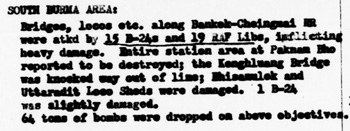
On this date, a planned attack on the Kaeng Luang bridge was thwarted by bad weather. This summary is from a narrative on the Mission Report:[9] Kenghluang Bridge. Six 491st B-25 crews briefed to attack Kenghlung railroad bridge, Thailand; alternate target Lamphan Rail and Road Bridge. The formation departed Yangkai at 0904 hours led by Lt Paul Ley. Weather encountered enroute to IndoChina border was 6/10ths cumulus, 12,500 feet tops, 9000 feet bases; 7/10ths, 13‑14,000' tops with bases lowering to mountain tops at 8,000' with scattered thunderstorms to the Mekong River; south of Mekong 8/10ths with tops to 16,000' and numerous thunderheads. The formation tried to get under this overcast at 18°30' N, 100°10' E, but found the ceiling zero and had to climb back up again. They then headed for the alternate target, Lambhan Railroad Bridge and found the same weather. So, returned to base; during which 43‑4160 and 43-3920 salvoed their bombs on uninhabited mountain sides near the Mekong River, near 20' N, 36' E, due to shortage of gasoline to reach base. All other bombs returned to base, planes reaching Yangkai at 1331 hours. The above includes a good example of problems with spelling of local place names. The alternate target, "Lamphan" is sufficiently butchered to refer to possibly either Lampang or Lamphun, which are only about 60km apart. Both locations had rail and road bridges, though Lampang was by far the more important target, and so was probably the intended one. There is also an error in the longitude for the location where bombs were jettisoned. If the latitude is correct, it intersects the Mekong near Luang Prabang at longitude E102°, not the stated E36°. So the jettison location would have been more likely N20° E102°. Transcription: SOUTH BURMA AREA: The key detail here: "knocked way out of line". The alignment of the bridge is next mentioned on 30 November. Again, the use of B-24 bombers indicates they came from the 10th Air Force in India.
On this date, a 10th Air Force B-24, captained by Charles E Meade, was shot down while attacking Kaeng Luang bridge. Mead and crew, plus a British news reporter, all died in the resulting crash. See page 2. No other report is currently available regarding this attack on the bridge.
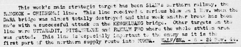
Transcription (emphases added): This week's main strategic target has been Siam's northern railway, the Bangkok-[Chiang Mai] line. This line received a serious blow on 1 Nov when the Dara bridge was almost totally destroyed and this week another break has been made with a successful attack on the [Kaeng Luang] bridge. Other targets on the line were Uttaradit [~50km SSE], [Phitsanulok, 140km SSE], and Paknam Pho [~250km south] where the whole station area was gutted. This line is especially important to the enemy as it is the first part of the northern supply route into Burma. WALF/SEA 8-24 Nov 44. The USAAF Chrono did not record the bridge as attacked by the 14AF on this date, but rather on 26 November (see next entry below); however 341st BG unit records did specifically mention the bridge on this date, as noted in the narrative in the mission report:[12] Seven 491st B-25s led by 1Lt. Fox departed Yangkai at 0400 hours and flew direct to attack the Kenghluang Rail and Road Bridge, IndoChina. The formation was a few miles off course when it reached the target area due to strong upper-level winds. Therefore, instead of the primary target, it attacked a railroad bridge at 18°17'N 99°47'E, about 17 miles westnorthwest of the Kengluang Railway Bridge, Thailand. At 0703 a twin-engine enemy bomber, single tail, was seen heading east and passing under the formation to avoid it. The enemy plane followed the formation to the target, kept a respectable distance, but visual contact was lost as formation started bomb run. Bombs were dropped at 0712 with the pattern starting about 300 feet beyond the bridge, only destroying a hundred feet of track and roadbed. Ten railcars were seen near three miles east of the attacked bridge and five railcars two miles north of the bridge. Returning to base, a formation of several unidentified aircraft were observed at a distance in the vicinity of Chienmai, and our formation changed course to stay away from it. All aircraft returned to Yangkai by 0953 hours. The substitute target was the three-span Mae Chang bridge which is the longest bridge between the Kaeng Luang bridge and Lampang. The approximate three miles east of the bridge, where ten railcars were observed, today roughly coincides with what appears to be a working quarry (N18°00.9 E99°57.0) on Google Earth, plus a siding subsequently noted (below) at the Kaeng Luang Railway Station. The two miles north of the bridge, where five railcars were sighted, would have been at the RR stationing for the Huai Mae Ta Railway Station; but no station structure is visible at that location on Google Earth. The USAAF Chrono incorrectly recorded the bridge as attacked on 26 November 1944 (see note above): CBI - THEATER OF OPERATIONS - CHINA (14AF): 19 B-25s and 20 P‑51s blast railway cars, station, and track, hit several trucks, and hit town areas at Hochih, China and Phu Lang Thuong, French Indochina. 6 B-25s damage a bridge at Kengluang, Thailand. 90+ P-40s, P‑51s, and P-38s hit river, rail, and road traffic and other targets of opportunity over wide S China areas, 40 of them concentrating on targets between Kweiyi and Changsha and around Liuchow, China. A flight of the 21(Photo)RS, 14AF, begins operating from Luliang, China with F-5s (squadron is based at Kunming). The use of B-25s indicates this was the 14th Air Force flying out of China. No more records of the Kaeng Luang Bridge being attacked have been found; however, records of observations continued.
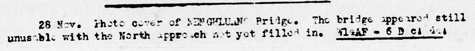
Transcription: 28 November. Photo coverage of [Kaeng Luang] Bridge. The bridge appeared still unusable with the north approach not yet filled in. W14AF-6D d: 4d: This is the first mention of damage to the north approach. The damage recorded on 31 May 1944 was to the south approach. Note that the paragraph credits 14AF, the 14th Air Force in China for the photo coverage.
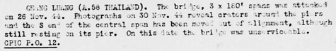
Transcription: [Kaeng Luang (Bridge No. A.58 Thailand)]. The bridge, 3 x 180 foot spans, was attacked on 26 November 1944. Photographs on 30 November 1944 reveal craters around the piers and the south end of the central span has been moved out of alignment, although still resting on its pier. On this date the bridge was unserviceable. This is the second mention of a problem with alignment: it was first noted after the attack on 19 November; hence the misalignment noted here was probably unrelated to the 26 November attack. With that assumption, the bridge was probably rendered permanently "unserviceable" as of 19 November 1944.
Transcription: 30 November 1944. [Kaeng Luang railroad bridge at] N18°03 E99°56. North approach to bridge is out, and no signs of repair are visible. Twenty railroad cars at mine siding 2.3 miles southeast of bridge. An important point here: if "the south end of the central span has been moved out of alignment," and, as a conclusion, "the bridge was unserviceable", there might seem to be no point in repairing the damaged approaches. However, usable approaches would allow railroad maintenance equipment access to possibly repair the damaged span. But a subsequent report addresses the failure to repair as evidence that the bridge structure was not being repaired; and a reason is then found. The siding described is at the Kaeng Luang Railway Station, at the same 2.3 miles southeast of the bridge. Sidings are a common feature of Thai railway stations. It is perhaps identified as a "mine siding" because of what now appears on Google Earth to be a stockpile in the station yard, with a 0.5km road to the south connecting to what appears to be a fair-sized quarry operation with similar stockpiles.
Transcription: 05 December 1944. [Kaeng Luang] railroad bridge at N18°03 E99°56. No repair noted on bombed out north approach to bridge.
The bridge was photographed on this date from 25,000 feet:
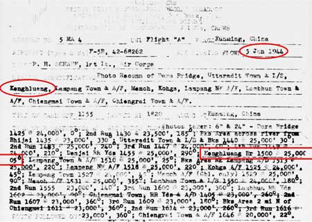
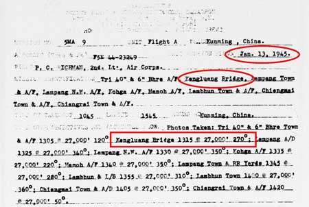
Transcription: 05 Jan 1945. P.C. [Kaeng Luang] railroad bridge [at] N18°03 E99°56. Bridge remains unserviceable. No repairs undertaken. W14AF-17 Jan 45. Here the 14th Air Force was responsible for the intel. Because the date of this sitrep and that of the reconnaissance flight described above were the same, it is likely that the photos from the recce flight were the basis for the sitrep.
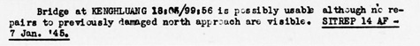
Bridge at [Kaeng Luang] at N18°03 E99°56 is possibly usable although no repairs to previously damaged north approach are visible. Again, the 14th Air Force was responsible for this intel.
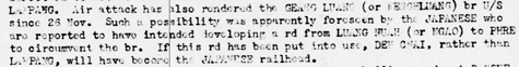
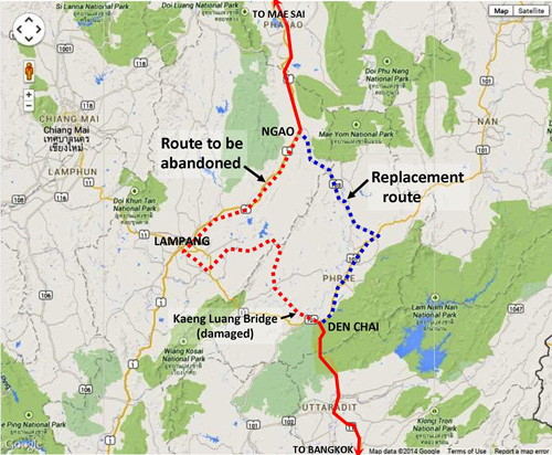
Here, interestingly, Allied intel suggested an explanation as to why repair work was not being observed on the Kaeng Luang Bridge: Transcription (emphasis added): . . . Air attack has also rendered the [Kaeng Luang] bridge unserviceable since 26 November. Such a possibility was apparently foreseen by the Japanese who are reported to have intended developing a road from Luang Nuah (or Ngao) to Phre [Phrae] to circumvent the bridge. If this road has been put into use, Den Chai, rather than Lampang, will have become the Japanese railhead. Referring to the map below, in rough terms, the original route included 110km of railroad track and 110km of road, while the replacement route involved only 80km of road. The disadvantages: the replacement route had to be improved and from low to high points, it was 125m greater than the original route.[16a]
Using present day Thai road numbers, the routing that would have been abandoned by the revision was: Den Chai - railroad - Lampang - Thai Route 1 north to Ngao. The revised routing for northbound traffic would have been Den Chai - Route 101 - Route 103 - Ngao. At Ngao, Route 1 was picked up for the run to Mae Sai.
The bridge was photographed from an altitude of 27,000 feet:
Available records show that the bridge was attacked on these dates:
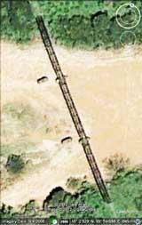
During the period 1949-1950, possibly as a gesture of friendship (war reparations would not have been exacted between allies), the Japanese government installed a replacement bridge a few meters to the east of the old site (as shown in the "Current View" above).[23]
|
See Key for interpreting page content. Revision list. See bottom of Text column on this page. Bibliography supports notes. 1.^ Source: Google Earth fix on center of bridge. 1a.^ Also: Geangluang, Kenghluang. The bridge is between two small railway stations: to the south, Kaeng Luang; and to the north and actually closer, Mae Ta. Allied intel chose to refer to it per the station to the south (Kaeng Luang). The bridge is known locally, and more realistically, as simply "Suphan Huai Mae Ta", or the bridge across the Mae Ta waterway (per Wisarut Bholsithi email, 1043 hrs 04 Feb 2013) The bridge is also sometimes called the Den Chai Bridge. Den Chai is a fair sized town about 17 km ESE of the bridge at the junction of current Thai Routes 11 and 101. The province capital, Phrae, about 22 km NNE of that town, accesses the northern railway at Den Chai's station via Thai Highway 101. And a moment of humor: while English letter sounds "L" and "R" are differentiated in the Thai alphabet as "ล" and "ร", some Thais pronounce them identically. Hence "Kaeng Luang" and "Kaeng Ruang" can sound the same, though the Thai spelling for "luang" and "ruang", "หลวง" and "เรือง", are considerably different. Point here: there is a Kaeng Ruang, but it is almost 700 km SE of Kaeng Luang and has no nearby railway. 2.^ Railway stationing: 551.553 (per semi-official: Stations and Stops in Thailand) As noted, the bridge was located roughly halfway between two stations: Kaeng Luang - 546.94 2a.^"Terrain" map from Nations Online Project: Searchable Map and Satellite View of Thailand using Google Earth Data. Annotations by author using Microsoft Publisher. 3.^ 21st Photographic Reconnaissance Squadron (hereafter 21PRS) Report Mission No. 13-4A, 09 Jan 1944 (USAF Archive microfilm reel A0878 p0197). The US National Archives and Records Administration (NARA) seems to act as "gatekeeper" for all government-related records. Downstream, the Air Force Historical Archive (USAFHA) holds aerial photo flight report texts while the US Army seems to hold the actual aerial photos. Hence availabilities of flight reports and actual photos are unrelated. 21st Photographic Reconnaissance Squadron(History and Lineage). Combat Squadrons of the Air Force World War II, 21st Photographic Reconnaissance (p 169).
3α.^ Tony Strotman, managing the website 341st Bombing Group, was able to assemble this detail based on unit records comprising the Operational Mission Report for the flight plus the 341st Bomb Group Monthly History Summary. The availability of this detail was a coincidence and the same detail is not necessarily available for all USAAF activities. This unit record plus those cited in subsequent attacks on the bridge include reports from the USAAF 341st BG proper plus two of its squadrons, the 22nd and the 491st. They are contained on USAF Archive microfilm, copies of which Strotman uses for research for the 341st website. Comment: Strotman also showed me a page from which he had gleaned some of this detail: the microfilm is almost illegible because of poor quality (several generation carbon copy plus poor quality microfilm reproduction). Unfortunately that is not uncommon for archive records. Hence, large lists of records shown in USAF archives indexes tend to be misleading as to the actual availability of information. The limited quality of microfilm records is the reason that, while I try to show images of extracts from original documents, I usually follow those extracts with transcriptions of their contents. Strotman pointed out another difficulty in using archive records, especially for targets in Thailand: non-standard spellings of locations. See below for more comment.
3å.^ Courtesy of Tony Strotman (mgr, website,
3a.^ 21PRS Report Mission No. 4 MA 72, 29 May 1944 (USAF Archive microfilm reel A0878 p0010).
3b.^ Hammel, Eric, Air War Pacific Chronology (Pacifica Military History. Kindle Edition, 2009), Kindle Location 12304). 3c.^ Courtesy of Tony Strotman (mgr, website, 3d.^ Sources: Stations and Stops in Thailand) Google Earth: RR stationing estimated using Google Earth path / elevation profile tool; bridge length using scale tool. Bridges either side of tunnel, progressing from south to north: 551+553:
4.^ "Print rec'd 7/24/44 from BPR [Bureau of Public Relations] . . . ." Photo source: NARA Reference No:
4a.^ fold3: Kenghluang Bridge. Strotman cautions: USAF WWII images posted on Fold3 were "released for publication" from an HQ Information Office where they had been deemed generally suitable for "propaganda" or "morale building". Annotations on Fold3 images were for newspaper and magazine use and were often inaccurate fluff. For this purpose, original negatives were copied while cropping out the original labeling. Then the new negatives and prints were annotated with non-classified information and would be included in a package with "For Publication" information. Following that, the photos were sent to higher HQ Information Offices, which had authority to release them, and would be distributed to official publications and/or civilian news media. Early-war releases usually failed to identify units, locations, or individuals, while later ones got more specific as the war progressed.
4b.^ fold3: "Knocking out Kenghluang Bridge" (extract).
5.^ Photo captioned: "Kenghluang [Kaeng Luang] Bridge in Thailand carried vital Japanese rail tonnage over the Menam Yom from the coast and Bangkok, north to advanced Japanese positions." and "Print rec'd 11/30/44 from BPR. Stamped: Passed for Pub, US Army Press Censor". Photo source: NARA Reference Number: Since the actual date of the photo is not available, this time sequence of 31 May bombing, followed by this undated repair, followed by 19 Jun bombing is only an assumption; however it does fit together nicely.
5a.^ ibid, extract. Annotations by author using Microsoft Publisher.
5a1.^ Courtesy of Tony Strotman (mgr, website,
5b.^ 21PRS Report Mission No. 4 MA 15, 16 Sep 1944 (USAF Archive microfilm reel A0878 p0441).
6.^ 21PRS Report Mission No. 4 MA 132, 25 Oct 1944
6a.^ India-Burma Air Force, Brief of Principal Air Operations (09 Nov 44), no page no, Item (26) of 06 Nov 44 (USAF Archive microfilm reel A8202 p0363).
6b.^ Road and Railroad Communications Report: Asiatic Area, for period 16‑30 Nov 1944, p 42, Item 4A07 of 06 Nov 1944 (USAF Archive microfilm reel A8044 p0269). Dates are correct: field reports apparently sometimes took a while to filter up the chain of command.
7.^ 21PRS Report Mission No. 4 MA 149, 11 Nov 1944
8.^ Road and Railroad Communications Report: Asiatic Area, for period 01-15 Nov 1944, p 25, Item 4A03 of 11 Nov 1944 (USAF Archive microfilm reel A8044 p0189).
8å.^ Road and Railroad Communications Report: Asiatic Area, for period 16-30 Nov 1944, p 41, Item 4A03 of 17 Nov 1944 (USAF Archive microfilm reel A8044 p0268).
8α.^ Courtesy of Tony Strotman (mgr, website,
8a.^ fold3: [Kaeng Luang] Bridge.
8a1.^ Extract from fold3: [Kaeng Luang] Bridge.
8b.^ fold 3: [Kaeng Luang] Bridge.
8c.^ Per Horizontal Sundial Shadow Angle Calculator.
9.^ Courtesy of Tony Strotman (mgr, website,
10.^ India-Burma Air Force, Brief of Principal Air Operations (19 Nov 44), no page no, Item (26), undated (USAF Archive microfilm reel A8202 p0349).
11.^ Road and Railroad Communications Report: Asiatic Area, for period 1-15 Dec 1944, p 38, Item 4A03 of 24 Nov 1944 (USAF Archive microfilm reel A8044-p0417).
12.^ Courtesy of Tony Strotman (mgr, website, Strotman cautions: Comparing USAF Chrono dates with Mission Report dates for 341st BmGp squadrons indicates to me that some, tho definitely not all, chrono dates for CBI have been adjusted for dateline difference to reflect the America equivalent date; ie, Chrono date = CBI date minus 1. In this instance, an editor bobbled the formula and redated the event on 26 Nov rather than 24 Nov.
13. (deleted).
14.^ Road and Railroad Communications Report: Asiatic Area, for period 15-31 Dec 1944, p 44, Item 4A03 of 28 Nov 1944 (USAF Archive microfilm reel A8044 p0344).
14a, b. (deleted).
14c.^ Road and Railroad Communications Report: Asiatic Area, for period 1-15 Dec 1944, p 44, Item 4A02 of 30 Nov 1944(?) (USAF Archive microfilm reel A8044 p0417).
14d.^ Transportation Report: Road, Railroad, and Inland Waterways: Asiatic Area, for period 15-31 Jan 1945, p 53, Item 4A03 of 30 Nov 1944 (USAF Archive microfilm reel A8044 p0556).
14e.^ Transportation Report: Road, Railroad, and Inland Waterways: Asiatic Area, for period 15-31 Jan 1945, p 53, Item 4A03 of 05 Dec 1944 (USAF Archive microfilm reel A8044 p0556) [NB: confirmed that notes 14d & 14e are on same ref page]. 14f. (deleted).
14g.^ 21PRS Report Mission No. 5 MA 4, 05 Jan 1945 (USAF Archive microfilm reel A0878 p0815). Note that form is incorrectly dated with 1944, not 1945: the first digit of the report number 5 MA 4 confirms 1945.
15.^ Transportation Report: Road, Railroad, and Inland Waterways: Asiatic Area, for period 1-15 Feb 1945, p 62, Item 4A03 of 05 Jan 1945 (USAF Archive microfilm reel A8044 p0641).
15a.^ Transportation Report: Road, Railroad, and Inland Waterways: Asiatic Area, for period 1-15 Jan 1945, p 23, Item 4A03 of 07 Jan 1945 (USAF Archive microfilm reel A8044 p0475)
16.^ Transportation Report: Road, Railroad, and Inland Waterways: Asiatic Area, for period 15-31 Jan 1945, p 54, Item 4A03 of 12 Jan 1945 (USAF Archive microfilm reel A8044 p0557).
16a.^ "Terrain" map from Nations Online Project: Searchable Map and Satellite View of Thailand using Google Earth Data. Annotations by author using Microsoft Publisher.
17.^ 21PRS Report Mission No. 5 MA 9, 13 Jan 1945 (USAF Archive microfilm reel A0878 p0807).
18. deleted.
19.^ ibid: closeup. 20.^ Photo captioned: "Kenghluang [Kaeng Luang]- War Theatre #11 (Thailand - BOMBING". Photo source: NARA Reference Number: 342‑FH&‑3A04824‑A59651AC via Fold3: (Thailand) BOMBING /A4824. Typed information on the back includes "North American B-25 Mitchells smash [Kueng Luang Bridge] Jap Lifeline in Thailand. 11/11/44". 21.^ Google Earth view:
22.^ Rotfaithai Gallery image DRC 00507. provides a present-day view of the bridge, looking NNW: to the left of the bridge in the river bed, directly below the power lines, can be seen one of the piers for the previous bridge which was destroyed in 1944. 23.^ Per Wisarut Bholsithi email, dated 1043 hrs 04 Feb 2013. My text corrected from west to east on 04 Jul 2014. 24-25. (deleted).
|