Japan in Northwest Thailand during World War II
| N17°57.1 E99°21.0[1] |
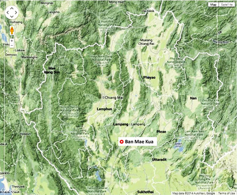
Ban Mae Kua[1a] (Th: บ้านแม่กัวะ / Jp: バンメイクア ) Crash Site Lampang Province - Interim Report 15 June 2014 Page 1 of 2 |
Thai Route 0001 Sta 000.00 [2] |
| Text | Notes | |||||||||||
|
Note these two pages about Ban Mae Kua and Franklin McKinney have been superseded by USAAF P-38 crashed at Mae Kua; Franklin McKinney killed.
BAN MAE KUA: Summary Ban Mae Kua is located about 40 km south of Lampang. It was of significance during WW2 only because a P-38 on a solitary reconnaissance (recce) patrol may have crashed in the area. The aircraft, piloted by 1st Lt Franklin H McKinney, disappeared on a routine 2,000 km aerial photo flight out of a USAAF base at Yunnanyi in China on 05 November 1944. Its intended destinations could have taken it over Mae Kua. A report about a crash at Mae Kua was discovered during recovery operations at the RTAF museum at Don Muang after a major flood in October 2011. Details about the crash in the report coincide with the probable flight plan of the aircraft. There is no information about the disposition of the remains of the pilot.[3]
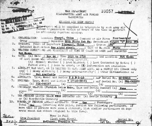
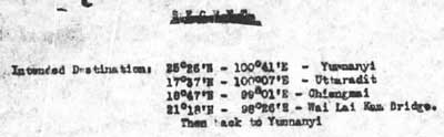
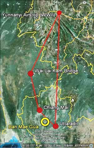
The missing crew report (MCR) for Franklin H McKinney provides no information about where he disappeared, other than his intended destinations. He was traveling alone on a photo recon mission which was to go from Yunnanyi in China, to Uttaradit and Chiang Mai in Thailand, then Wai Lai Kam Bridge in Burma, and finally back to Yunnanyi. As far as records of the day were concerned, McKinney just simply never returned from his flight:[04a]
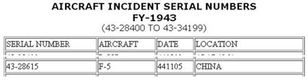
The MCR includes hand drawn maps with locations where aircraft in circumstances differing from McKinney were apparently reported down in China. The maps extend as far north as Hankow (N30°37 E114°18, now Wuhan) and as far south as Kuei-Lin (N25°17 E110°17, now Guilin); but no location is associated with McKinney. The only solid information at that time was his intended flight path:
On Nov 5, 1944 at about 1340 hours during a rain storm, there was a plane with 2 engines and 2 tails flying through the storm. Apparently, the plane was hit by lightning strike. People on ground heard an explosion and saw a burning plane went down and crashed. The location was at a wooden area in Ban Mae Gua, Sobprab Sub-District, Lampang Province.[05] Subsequent investigation revealed the plane as a P-38, "NUMBER 811,"[05a] with white star in dark blue circle marking. A skull was also found in the wreck.[06]
The general location of the apparent crash site, "Ban Mae Gua" (with circle in yellow below) is consistent with McKinney's flight plan (traced in red below):
The crash site named in the RTAF report is Mae Gua. The Royal Thai Survey Department (RTSD) transliterates the Thai spelling, แม่กัวะ, as Mae Kua. The latter spelling appears in commercial road maps and on the Internet, and is used here. The name may refer either to the subdistrict (tambon as อบต.แม่กัวะ) or the town (ban as บ้าน.แม่กัวะ) within it. While the RTAF report is specific in naming the town, not the subdistrict, the terms are commonly used interchangeably:[13]
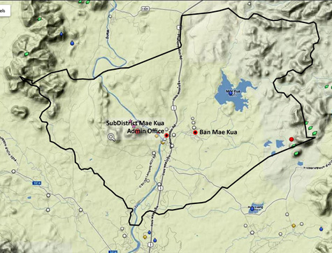
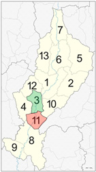
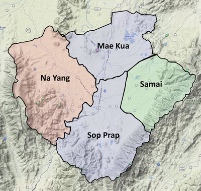
The solid black line on the map above represents the current boundary of Mae Kua Subdistrict, which encloses a land area of 103 sq km.[14] The situation is complicated by two factors: 1. Mae Kua Subdistrict is part of Sop Prap District (อบต.สบปราบ). The history of the current Sop Prap District boundary appears somewhat fluid: from 1917 to 1953, it was subordinate to Ko Kha District which is directly to the north[15] (this presumably was brought about by the same influences in Ko Kha which were successful in getting Thailand's first 20th century sugar mill located there[15a] plus a pre-WW2 airstrip[16] adjacent to the plant):[16a]
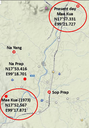
2. In 1953 or thereafter, the three subdistricts composing Sop Prap District evolved into four. Mae Kua had been among the earlier three;[17] however, land was apparently borrowed from both Mae Kua and Sop Prap Subdistricts (in blue below) to form the fourth, new subdistrict, Na Yang (in red below) . This would substantially increase the potential target area (and the present day search area) for the "Mae Kua" that McKinney crashed in, in 1944:[17a]
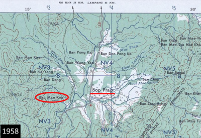
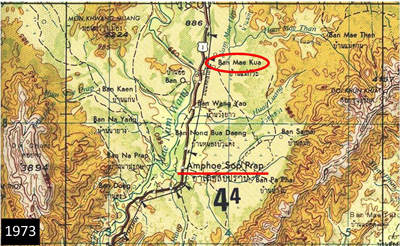
With the current boundaries of Subdistrict Mae Kua possibly different in 1944 when McKinney reportedly crashed there, this could also have contributed to a potential location mix-up (see directly below). Further, we don't know if the changes in 1953 were communicated to the US Army mapmakers in time for their 1958 edition: while they did not mark subdistrict boundaries, the existence of the boundaries could have affected their conclusions on place names. a. In the 1958 edition of the US Army Corps of Engineers map of the area, NE47-11 (Uttaradit), a 'Ban Mae Kua' appears at N17°52.6 E99°17.9 (Google Earth coordinates):[18]
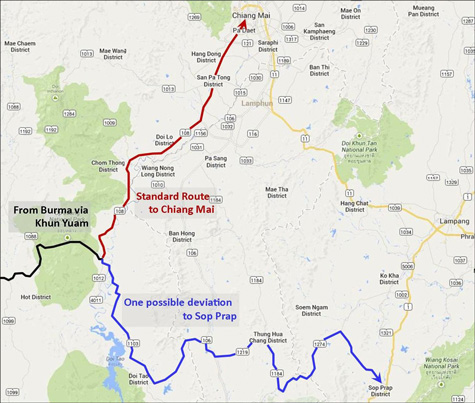
In mid-March 2014 (exact date lost), Milady and I visited the district maintenance facility at Sop Prap (อำเภอสบปราบ): its jurisdiction includes the subdistrict office of Mae Kua (ตำบลแม่กัวะ).[21] We met with the supervisor, Mr Supod Udthep (ทสพ ดบปราบ), who seemed enthusiastic about our questions. He was generally aware of the event, telling of an interesting story he had heard from his mother years before. She had only recently died, but he knew of one of her friends who might be able to verify and add details. He gave us his phone number and suggested we call him back in a few days (we did, but he said that the friend was suffering from dementia). His mother's story went something like this: Shortly after the end of the war, a group of Japanese soldiers came in from the west, traveling cross-country, to encamp at Ban Na Yang (บ้านนายาง)[22]. They weren't aware that the war was over and, on sighting a group of Indian soldiers at Ban Na Prap (บ้านนาปราบ)[23] fired on them. That was the end of the story: ie, there was no conclusion stated, though it can be assumed that the IJA troops were annihilated. The story came up because the fire fight was said to have been located at McKinney's crash site. The story has interesting aspects. 1. The IJA troops had probably trekked from Burma through Khun Yuam to take the south route via Mae Sariang and Hot towards Chiang Mai; but at Hot for whatever reason they had continued generally southeasterly. The road system exists today to support such a journey to Sop Prap, though back then it was probably nothing more than local foot trails and oxcart paths:[24]
3. British Army records may be able to confirm the incident, but I don’t believe such detail exists in the summary texts I have. They would certainly not identify the location as having been McKinney's crash site. On Monday, 12 May 2014, Milady and I visited Mae Kua. We first checked in with the Tambon Mae Kua office on Thai Route 1.[26] No one there recalled anything about an airplane having crashed in the area during WW2. We asked for a recommendation for a wat to ask at and were pointed at Wat Ban O (วัดบานอ้อ).[26a] There we learned that all the monks, including the lead monk, Siwaroj Piyaratsere (ศิวโรจน์ ปิยรัตน์เสรี), were out for the day on duties, but would be back the next day. On Wednesday, 14 May 2014, we returned to find a group of monks was getting ready to be driven off to perform a ceremony. Milady talked briefly with the lead monk, who was comparatively young, explained our purpose, was sympathetically received, and was told that they would return after lunch. An obviously elderly monk was with the lead monk and Milady said he showed no sign of recognition about the incident. That was not a good sign. Conversely, the lead monk professed to be a "seer" and claimed that he detected some entity (equivalent of a spirit) accompanying me; so that was a positive sign, in that he believed that he saw a someone I was searching for. While awaiting their return, we ventured across Thai Route 1 to the town of Mae Kua, sought out Wat Mae Kua[27], and queried a monk who was apparently in charge. He was unaware of such an incident, and gave us directions to the oldest man in town. When we finally found him, he also knew nothing of the incident. After the lunch break, we got together with the chief monk at Wat Ban O. He was 45 years old and recalled when he was 13 being told about such a crash by an 80 year old resident. However, he was aware of few details and didn't know where the crash had occurred. One item he emphasized was that the colors on the aircraft had been blue and white, which could generally fit the USAAF roundel:[27α]
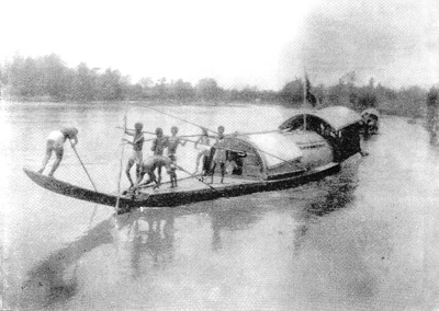
Such would be consistent with the RTAF report. And he recalled that the old man had spoken of seeing IJA troops shortly after the end of the war rafting down the Wang and hearing them laughing, apparently at relief that the war was over. The monk did paint a vivid picture of what it must have been like in this area during the war. I had heard and read similar explanations before. Putting together what he told about with what I already knew, this scenario arose:[27a] Conditions in Thailand during WW2 were very different from those of today. Route 1, the main north-south road, the Phahonyothin Road, connecting Mae Sai at the Burmese border with Bangkok, the capital far to the south, varied substantially in quality over its length. Between Lampang and Mae Sai to the north, it was an all-weather road, providing the main connection between the rail line and the border.[28] The 10 km connection between Lampang and Ko Kha to the south had also been improved as a part of the sugar refinery construction in 1937. Mae Kua, however, was 30 km farther south of Ko Kha, and the Phahonyothin Road in that distance dwindled to nothing more than a rutted oxcart trail. Mae Kua was a very isolated subdistrict through which the Wang River flowed south. Villagers' concept of the technology of water transport upstream was captured in this photo:[29]
Reliance on such a basic method of transport along the Wang stopped rather suddenly when rail service reached Lampang in 1916;[30] but the railroad was never closer to Mae Kua than the 40 km trip to Lampang. Thus villagers' concepts about advancing technology were frozen in time by their isolation. Some river traffic did continue downstream, with the current carrying teak logs destined for the Bangkok area: they were too big to transport economically by rail (logging stopped during the war). A ferry served as a bridge between communities on either side of the river. Those communities were very small. Some people never left the confines of the villages of their birth in their entire lives. Others on occasion did walk the day or more necessary to get to Lampang. Most were illiterate,[31] hence there was no need for newspapers. Broadcast radio was in its infancy and far to the south around Bangkok. Further, there was no electrical service in Mae Kua to power a radio receiver (though crystal radios did not require power and were in use). And to complicate matters, Thai bureaucracy had required all radio receivers to be licensed up to 1939.[31a] Extrapolating from Pannengpetch's portrait of a rather basic rural life, there doesn't seem much reason to assume that anyone would have had a clock or a pocket watch (to note the time of McKinney's crash with any precision). Villagers were generally afraid / suspicious of all outsiders. A recent history of visits by extortionist tax collectors had probably reinforced an exaggerated xenophobia.[32] There had been no projects like the government-sponsored sugar mill in Ko Kha, nor the Japanese efforts to develop airstrips at Hong Chat and Mae Mo, which might have served to favorably introduce Mae Kua residents to outside influences. Japanese soldiers, even Thai soldiers, shared that victimization; as did probably an Allied pilot blown out of the sky by a lightning bolt. When McKinney's plane crashed in the Mae Kua area, it could be assumed to have continued burning, consuming both aircraft and pilot; a section of the aircraft bearing a roundel probably broke away during the descent and survived to be described in the RTAF report. Local residents likely collected what human remains could be identified, perhaps only a skull as reported, and took the collection to the wat where it was respectfully cremated in the traditional Buddhist manner. A lesser known aspect of this process: the ashes and any solids remaining were unceremoniously shaken out onto the ground adjacent to the crematorium. At the end of each year, some crematorium grounds were "cleaned" by sweeping up the accumulation of a year's cremations into a pile and then setting off powerful fireworks in the pile to scatter the contents of the pile.[33] The closest telephone was probably in Ko Kha, 30 km north via an oxcart track. How soon authorities were notified, and how quickly they were able to respond, can only be speculative; however, the measure would have been in days. At that late point in the war, it is unlikely that either Thailand or Japan had the resources to salvage what remained of the P-38. Its disposition probably occurred over a period of years as cash-hungry villagers broke up components into manageable size for transport by ox cart to salvage yards in Lampang. Thus the monk was saying that it was improbable that anything now remained of either pilot or aircraft; and that is the dominant conclusion now, pending any results of further investigation to the contrary.
|
These pages were composed to be best viewed with Google Chrome. See Key for interpreting page content. Revision list. See bottom of Text column on this page. Bibliography supports notes. 1.^ Source: Google Earth coordinates for Tambon Mae Kua Admin Building on Route 1; used pending determination of location for crash site. 1a.^ Mae Gua, on RTAF report. 2.^ By author inspection 3.^ "Terrain" map from Nations Online Project. Annotations by author using Microsoft Publisher.
04.^ Enquiries are in progress on this particular event: some of the information needs additional support.
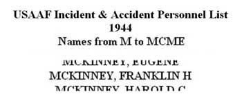
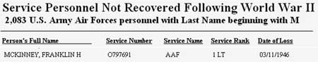
04a.^ "Individual Report of Downed Aircraft", Missing Air Crew Report" No. 10057, Report Date: 08 Nov 1944, p 2 (extract). 35th Photographic Reconnaissance Squadron (CBI Order of Battle: Lineages and History) Combat Squadrons of the Air Force World War II, p 169.
04b.^ ibid, p 3 (extract).
05.^ "Ban Mae Gua, Sobprab Sub-District". Per RTSD titles: Ban Mae Kua, Sop Prap Sub-District, in Lampang Province: located at N17°56.6 E99°21.0 per Google Earth. 05a.^ Some of the basis for the number "811" is given at The 35th Photo Reconnaissance Squadron. 06.^ The origin of the English language text is Captain Sakpinit Promthep at the RTAF Museum at Don Muang. The texts provided to both Forgotten Squadron Research (per Dan Jackson email of 01:56 12 Oct 2012), and Steve Darke (and presented in Thai-Aviation's Aircraft Accidents compilation, p 2, dated 02 Sep 2012) are identical. Item is not listed in "November 1944 USAAF Overseas Accident Reports". 7. (deleted). 08.^ USAAF Incident & Accident Personnel List 1944. 09.^ Aircraft Incident Serial Numbers. Note "serial number" refers to the number assigned to the incident, and starts with the FY (two digit); here it is for FY 1943. However, the event occurred in Nov 1944, which was actually FY 1945, since a FY is numbered as the year in which it ended, which in this instance would have been 30 Jun 1945. There is another instance of date error in this source; see Henry Minco. 10.^ 1943 USAAF Serial Numbers. 11.^ Service Personnel Not Recovered Following World War II. This date error might have been the result of the reporting agency reclassifying an MIA as a KIA or as an "MIA declared dead", with a possible time lag of a year or more. Problems specific to the European Theatre are discussed in detail in Miller, Robert S, America's Abandoned Sons (Bloomington IN: Xlibris, 2012), pp 575-576 and probably have applicability to the Southeast Asia Theatre. Thanks to Lt Col Terry Popravak, USAF (retired), of 142FW/HO (and maintaining The 35th Photo Reconnaissance Squadron website) for pointing this out (per his email of 1340 09 Feb 2014). 11a.^ The Official Chronology of the US Army Airforce in World War II: 1944. Lt Col Popravak (see note 11above) clarifies that the official USAAF chronology did not list individual aerial photo missions, nor were records reliable in listing unit relocations such as that of his 35PRS (his email of 1340 09 Feb 2014). 12.^ Google Earth "Yunnanyi Airstrip", now Xiangyu Airport or Xiangyun Midu Air Base is located about 19 km ESE of present day Xiangcheng (see also TopoMapper dual view). "Wai Lai Kam Bridge", has apparently been replaced by the 4,000m long Kunhing Bridge, spanning the Nampan River, on the Taunggyi-Kengtung Road (Burma Route 4). 12α.^ Distance per Google Earth "Elevation Profile". The 2,000 km distance makes no allowance for aerial photo flight patterns over the three "targets". Thus the distance to have been flown would have been somewhat greater.
13.^ "Terrain" map from MapCarta. Annotations by author using Microsoft Publisher. 14.^ อบต.แม่กัวะ – อำเภอสบปราบ – จังหวัดลำปาง
15.^ Wikipedia: Sop Prap District History. 15a.^ Nožina, Miroslav, Siam Undiscovered (Bangkok: Amarin, 2004), pp 87. 16.^ Squadron 61 was recorded as located at Ko Kha on 22 Dec 1941. 16a.^ Wikipedia: Lampang Province Administrative Divisions.
17.^ Wikipedia: Sop Prap District History.
17a.^ "Terrain" map from MapCarta. Boundaries fitted from Google Search Map Data results for the four subdistricts shown. Annotations by author using Microsoft Publisher.
18.^ Perry-Castañeda Library Map Collection, University of Texas at Austin
19.^ ibid.
20.^ "Terrain" map from MapCarta. Distance and coordinates per Google Earth "Ruler" utility. Annotations by author using Microsoft Publisher.
21.^ Need coordinates.
22.^ N17° 54.93 E99° 18.24 23.^ N17° 53.42 E99° 18.70
24.^ "Terrain" map from Nations Online Project. Annotations by author using Microsoft Publisher.
25.^ "Terrain" map from MapCarta. Distance and coordinates per Google Earth "Ruler" utility. Annotations by author using Microsoft Publisher.
26.^ N17°57.1 E99°21.0 26a.^ N17°56.67 E99°20.63
27.^ N17°57.33 E99°21.73
27α.^ Other VPI Links.
27a.^ An extraordinary in-depth presentation about rural village life in Lampang Province in the mid-1960s is available in Pannengpetch, Sakda, The influence of radio broadcasting on rural development (Durham, UK: Durham University, 1984). Much of the detail about Ban Naa Dong (in Mae Pa area, approx N17°38 E99°14) would have been applicable to Mae Kua during WW2. The Mae Pa area is about 37 km south of Mae Kua on Thai Route 1. 28.^ Need reference.
29.^ Boonserm Satrabhaya,
30.^ Ongsakul, Sarassawadee, History of Lanna (Chiang Mai: Silkworm, 2001, translated by Chitraporn Tanratanakul, 2005), p 245-246.
31.^ Education for All Global Monitoring Report, (UNESCO 2006), p 197 31a.^ Pannengpetch, ibid, p 170.
32.^ Ongsakul, ibid, pp 229-246.
33.^ I've attended perhaps a dozen Buddhist funerals in Chiang Mai and one in Uttaradit over my 12 years here. Funeral ceremonies in Thailand are described in some detail on several websites. The only presentation that comes close to my experience is at What to expect if you are invted to a Thai Funeral. I'm not familiar with most of the details in Buddhist Funeral Rites in Thailand . . . and at Thai Funerals-the Checklist. Note also that none of the three descriptions agree. This is consistent with observations that traditions are strong and differ from one wat to another, and from one locale to another. And none of them mention the annual cleaning of the crematory grounds.
|
|||||||||||