Japan in Northwest Thailand during World War II
| N18°11.90 E99°24.67[1] |
Ko Kha[1a] Landing Ground (Th: เกาะคาท่าอากาศยาน/ Jp: コカ滑走路) Lampang Province Page 1 of 3 |
Route 0001 Sta 690~ [2] |
| Text | Notes |
|
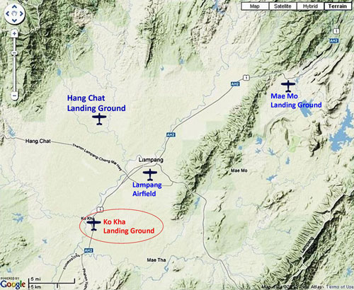
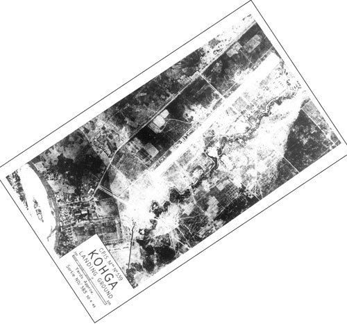
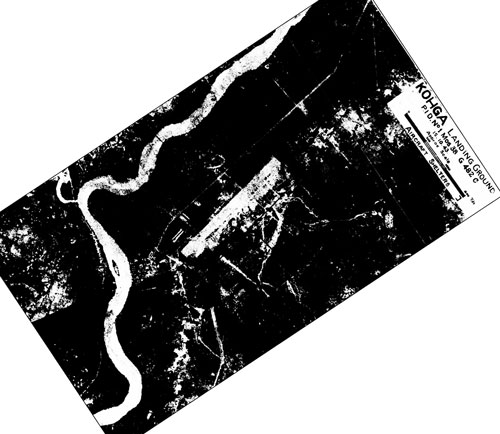
Ko Kha: Summary Prior to the war, the Royal Thai Air Force (RTAF) operated the Ko Kha Landing Ground; during the war, the Imperial Japanese Army Air Force (IJAAF) incorporated it into the Lampang Airfield Group as its southerly satellite air facility. Its single roughly northeast-southwest runway was located about 11 km by air southwest of Lampang Railway Station (the reference point used by Allied intelligence during WW2), and about 13 km by air from the Lampang runway. No aircraft were ever observed there. After the war, any aircraft function was apparently terminated with the land converted to various mainly public functions, which continue today. Aerial photo reconnaissance reports included here record coverage of Ko Kha Airstrip (Kohga Landing Ground) by only the 21st Photographic Reconnaissance Squadron (21PRS) starting in January 1944. Aerial photos by other units exist, such as that by 40PRS, but it is very limited and associated reports appear not to have been released as of November 2012.[2a1] No WW2 era photos of the facility have been found as yet, other than the poor quality mimeographed (?) copy published in October 1943 and shown directly below. That photo was obviously the basis for the excellent map sketch, both of which firmly locate the site. The airstrip at Ko Kha is assumed to have been established by the RTAF sometime prior to 22 December 1941, which is the date that it was recorded as the existing headquarters for Wing 80 (see below). Ko Kha apparently long had some special (political ?) significance for it was singled out in 1937 to be the site of Siam's first 20th century sugar refinery. It was built by Skoda Works (Czechoslovakia) under contract with the Thai Ministry of Agriculture. Its initial processing capacity of 500 tons of cane per day was increased to 800 tons in 1939. Included in that development was a small rail system providing connections between cane fields and the factory --- but without connection to the Royal State Railways of Siam system, which was 11 km north.[2a2]
The Thai government cooperated with Japan by sending the Northwest Army to help IJA troops in combat. . . . Wing 80 was under control of the Northwest Army and located in Ko Kha . . . [and] it moved [from Ko Kha] into place [Lampang] on 22 December 1941.[2a3] Squadron 61, part of a separate Combined Group in the Northwest Army, was located at Ko Kha. The unit consisted of Nakajima Ki-21 heavy bombers.[2a3a] That said, it is curious that the Ko Kha airstrip was not listed in the US War Department's A Survey of Thailand (Siam), dated 15 Mar 1941. That publication claimed its listing included facilities under construction.[2a4]
The unit (whether Squadron 61 or 62) of Nakajima Ki-21 heavy bombers was relocated to Lom Sak Air Base in Phetchabun.[2a4a]
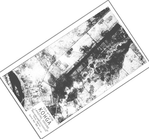
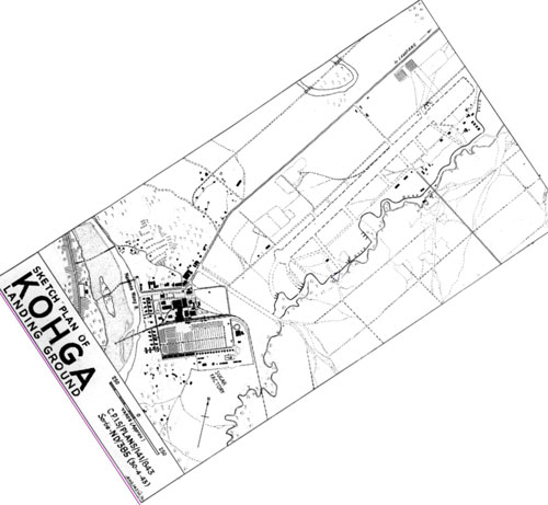
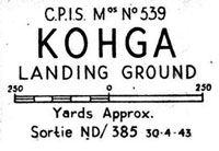
It is possible that the image above may actually be a negative. Just for argument's sake, here is the same image with blacks and whites reversed: Neither view appears quite right. While the second view makes the water in the river at the bottom of the photo look like a water surface, other details do not appear so straightforward. And this map sketch would appear to have been traced directly from the photo above: A larger scale image of the map sketch above is available here. For record purposes, the runway as depicted here measures 1,500 yards (1370 m).
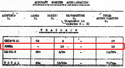
Allied aerial photography analysts counted 10 "aircraft shelter accommodations" at the Ko Kha installation: From a cursory viewing of the map sketch above, it is not clear how that number was derived. Detail on the aerial photo is insufficient to verify this count.
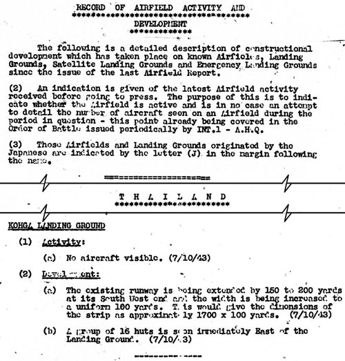
Construction was noted to be in progress to extend the runway 150-200 yards at the south end. That would have increased the runway total length to possibly 1700 yards (1550 m). Hence this would confirm the existing runway length as about 1500 yards, as scaled off the April 1943 photo and map above. If the extension were completed, the end of the runway would have been about 300 yards from the sugar plant property:
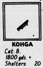
This is a so-called "miniature" for the Ko Kha airstrip, an abridged depiction, standard in Airfield Reports: The runway in the map sketch above dated 30 April 1943 measures 1,500 yards. The airfield development statement dated 07 October 1943 recorded that the runway was being extended by 150-200 yards, which would make a new length of 1,700 yards. However, the length of the runway in this and all subsequent miniatures is stated as "1800 yds+". But all subsequent report texts about the Ko Kha airstrip give its length as 1,700 yards, or 5,100 feet. (with the exception of one report dated 01 March 1944 with 1,600 yards)
The terms "surfacing" and "metaling" are discussed here.
|
These pages were composed to be viewed best with Google Chrome. See Key for interpreting page content. Revision list. See bottom of Text column on this page. Bibliography supports notes. Jack Eisner, lecturer, Chiang Mai University, was of critical assistance in developing this topic. 1.^ Source: Google Earth. 1a.^ Also Kohga, Koh Kha, Go Ka, Gorka. The first part of the place name, Ko, or เกาะ, is defined as island in Thai. With regard to Ko Kha, it apparently refers to a time when the meandering Wang River had carved out paralleling channels to form a temporary island. Note: not listed in Air America's Air Facilities Data Thailand 432, 1971. 2.^ Site visit required for route stationing. 2a.^ "Terrain" map from Nations Online Project: Searchable Map and Satellite View of Thailand using Google Earth Data. Annotation by author using Microsoft Publisher.
2a1.^ See page on USAAF Aerial Photographic Intelligence. 2a2.^ Information found by Jack Eisner in "Economic Relations Across Oceans", in Nožina, Miroslav, Siam Undiscovered (Bangkok: Amarin, 2004), pp 86-88. Added on 15 Jun 2014: The track was apparently still intact in 1971 since it is shown in RTSD map entitled Amphoe Ko Kha of that date. The collector lines are described in BR Whyte, The Railway Atlas of Thailand, Laos, and Cambodia (Bangkok: White Lotus, 2010), p 131, and are listed in Stations and Stops in Thailand. This mill was the beginning of an effort by the Thai government to recover from unfavorable trade treaties with European countries imposed in the 1870s. (deduced from Doner, Richard F and Ansil Ramsay, "Growing into trouble: institutions and politics in the Thai Sugar Industry", Jl of East Asian Studies, 2004). Added 01 Aug 2014: Two locomotives possibly used on the Ko Kha sugar railway in the war: Baguley and OK, both listed in Michael Pass's Preserved / Extant Steam Locos and Steam Cranes in Thailand. The mill's operational status during the war is unknown. 2a3.^ บระวัติกองทัพอากาศไทย 2a3a.^ ibid, item 2, p 278. Conversely, Young recorded Squadron 61 as having the Martin 139W (export version of the Martin B-10) and Squadron 62 as having the Nakajimas (Young, ibid, p 266). Young did not place either unit at Ko Kha. 2a4.^ A Survey of Thailand (Siam), (Washington: US War Department, March 15, 1941), Appendix I - Airdromes, Landing Grounds, and Seaplane facilities of Thailand, v. Additional Airdromes, Landing Grounds and Seaplane Facilities of Thailand, "correct up to April 1940", p 89 (USAF Archive Microfilm Reel B1750 pp1810-1813). 2a4a.^ Japanese Aircraft in Royal Thai Air Force and Royal Thai Navy Service During WWII by Jan Forsgren. The date of the relocation is not given [added 29 Sep 2014]. 2b.^ Airfield Report No. 15, Oct 1943, unnumbered page Note that while published in Oct 1943, the photo itself was dated 30 Apr 1943 (at bottom right):
Comparison of details on this photo with those available today establishes the bearing of the runway as almost exactly 045/225. All images from Airfield Reports are believed to have been degraded by, one, mimeographing for distribution at issue, and, two, later microfilming for the permanent records from which these images have been obtained. 2b1.^ ibid.
2c.^ Airfield Report No. 15, Oct 1943, unnumbered page
2d.^ Airfield Report No. 15, Oct 1943, pp 7, 9 (USAF Archive microfilm reel A8055 pp 0160, 162).
2e.^ Airfield Report No. 15 (Oct 1943), "Record of Airfield Activity and Development", pp 10, 29 (USAF Archive microfilm reel A8055 pp 0163, 182).
2f.^ Airfield Report No 16, Nov 1943, unnumbered page (USAF Archive microfilm reel A8055 p0195).
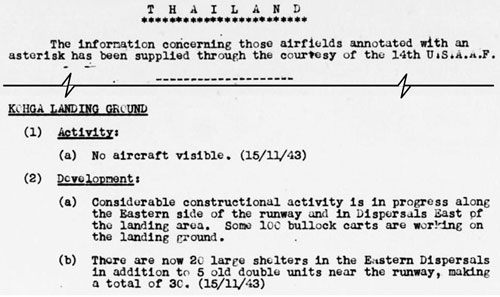
2g.^ Airfield Report No. 16 (Nov 1943), unnumbered page (USAF Archive microfilm reel A8055 p 0231).
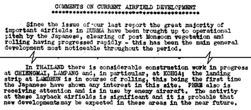
2h.^ Airport Report No. 16 (Nov 1943), "Comments on Current Airfield Development", page III (USAF Archive microfilm reel A8055 p 0236).
2i.^ Airport Report No. 16 (Nov 1943), "Record of Airfield Activity and Development", page 21 (USAF Archive microfilm reel A8055 p 0276).
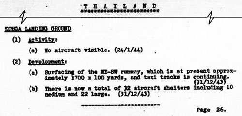
2j.^ Airport Report No. 18 (Jan 1944), "Record of Airfield Activity and Development", page 26 (USAF Archive microfilm reel A8055 p 0469).
|