Japan in Northwest Thailand during World War II
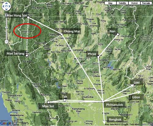
| N18°49.316 E97°55.791[α] | Khun Yuam Airstrip[β] (Th: ท่าอากาศยานขุนยวม / Jp: クンユアム滑走路) page 1 of 2 |
Route 0108b[γ] Station 197 |
| Text | Notes |
|
Khun Yuam Airstrip and air activities in the area, up to 1945 The airstrip at Khun Yuam was previously thought to have been a product of WW2. However additional information now shows it to have been in existence in June 1942:[0]
Its Type "E" is defined as "Emerency fields (Military or Civil) either of small size or having few facilities or both."[a] It is also listed in that reference with the title:[b]
To have been recorded as in existence that soon after the war started implies that it probably existed prior to the war as a part of the commercial network built by Thailand's Aerial Transport Company to handle both mail and passengers. did not exist before the start of WWII: it is not mentioned in air facility records through 1941 as summarized in the map below (the empty area circled in red denotes the present location):[1]
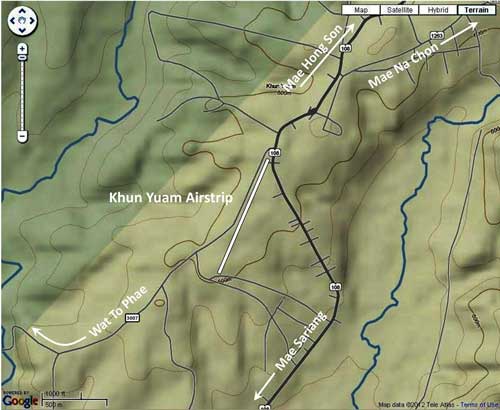
Closeup of Khun Yuam Airstrip location[5]
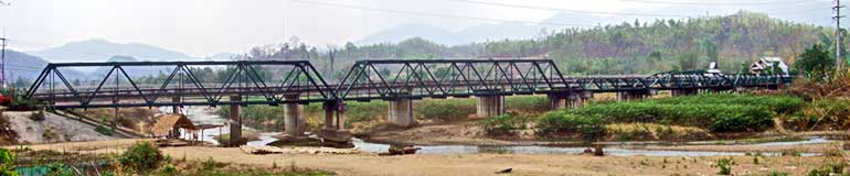
ORIGINS The official Japanese military history of WWII[7] does record that, in preparation for the IJA 1944 invasion of India, a vehicle road was to be established connecting the railhead in Chiang Mai, Thailand, with the road, river, and rail[7a] junction in Toungoo, Burma. That road was to pass through the border town of Khun Yuam in Thailand. The following IJA units were assigned to build the road:
They were given two months to complete the work. As the Japanese military history notes:
Thus, when it became obvious that the time required for the road improvement project has been grossly underestimated, the effort was largely abandoned on 09 Nov 1943, three months after the order had been given, and most of the IJA units assigned to the work were sent on to Burma via the Lampang-Kengtung Road.[12] |
See Key for interpreting page content. Revision list. See bottom of Text column on next page. α.^ Google Earth: center of runway. β.^ Also Kun Yom, Khun Youem. Name is derived from the river Yom / Yuam (clarification: from 1900 to 1917, the area was known as Muang Khun Yom / Yuam and Mae Sariang area was known as Muang Yom / Yuam (Wikipedia)). γ.^ Thai Route 108 runs continuously from Chiang Mai to Mae Hong Son. The road stationing starts in Chiang Mai at 0+00 to increase to ~88+00 at Hot; there it zeroes again (stationing equation 88+00=0+00) to again increase to ~265+00 at Mae Hong Son. The highway department apparently does not differentiate the two sequences; here I designate them 108a and 108b. 0.^
Airport Directory: South East Asia (Bujrma, French Indo-China, Malaya, Thailand) a.^ Ibid, p v. b.^ Ibid, p xvi. 1.^ The map is a composite of information from Young, Edward, Aerial Nationalism (Washington: Smithsonian Institute, 1995), p ix, and A Survey of Thailand (Siam), (Washington: US War Department, March 15, 1941) p 101, "Civil Air Routes (Jan 1940)", (USAF Archive Reel B1750, p1811), superimposed on a "Terrain" map from Nations Online Project: Searchable Map and Satellite View of Thailand using Google Earth Data. Annotations by author show solid white lines per Young and lines unique to US War Department as dashed. 2.^ Young, Edward, ibid. 3.^ ibid, p ix. This source showed Mae Hong Son as active, 1939-1941, while Khun Yuam was not shown. 4.^ A Survey of Thailand (Siam), ibid. This source indicated that airstrips at Mae Hong Song and Mae Sariang were "under construction" as of Apr 1940. 5.^ "Terrain" map from Nations Online Project: Searchable Map and Satellite View of Thailand using Google Earth Data. Annotation placed with Microsoft Publisher by author. 6. deleted. 7.^ 戦史叢書 (Sensi Sosho) (Japanese Military War History Series) 7a.^ By this time, however, one of the two sets of railroad tracks had been "taken up" per Brown, Atholl Sutherland, Silently into the Midst of Things (Victoria BC: Trafford, 2001), p 40 8.^ This date is generally confirmed by a statement later in the Senshi Sosho text referenced below: "The Army Group, on 12 August 1943, gave the order to prepare for the Imphal operation to the 15th Army" (p 148). 9.^ 戦史叢書 : Vol 15: インパール作戦―ビルマの防衛 10.^ ibid, p 140. 10a.^ Road distance between Toungoo and Chiang Mai was actually much greater: almost 650 km (See Toungoo-Border Pt 13 and Border Pt 13 - Chiang Mai). Flight distance was less at 270 km (per Google Earth). 11.^ 戦史叢書 : Vol 15, ibid, p 178. 12.^ ibid, p 179. |
|
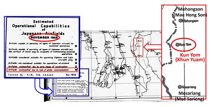
Ironically, even though the IJA abandoned the Chiang Mai-Toungoo road project in November 1943, in that same month, Allied intelligence began recording the existence of an air facility of some sort at Khun Yuam:[12a]
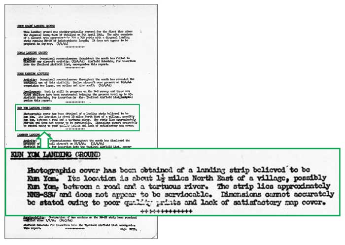
An April 1944 Allied intelligence report offered this amplification:[13]
| |
| Text | Notes |
|
Individual paragraphs within Allied published intelligence reports sometimes included dates when actual observations were made. In this case, unfortunately, the observation can only be keyed to the more general date of the Airfield Report, ie, here, No 21, April 1944. It can be assumed however that the "photographic cover" actually occurred in November 1943, or before, as evidenced by the dated map in the previous entry just above. Some details provided in the description do not conform well to the actual situation at Khun Yuam. . . . location is about 1 1/2 miles northeast of a village, possibly Khun Yuam . . . : another unfortunate aspect here --- the aerial photos are not available to verify the text. There is a village about that distance southwest of the airstrip: Ban To Phae, and it was shown as very sparsely built up in RTSD map 4546 I, dated 1992, the earliest map available. However, curiously, the airstrip is directly across the main north-south road from the largest wat complex in Khun Yuam, around which houses were shown grouped in that same map. There is no comparable grouping of structures in the area. . . . between a road and a tortuous river. . . : the airstrip is actually located west of both the main north-south road (now Rte 108) and the Yuam River. The road actually touches the northeast corner of the airstrip before wandering southeasterly to eventually cross the tortuously twisting and turning Yuam River as it turns west. Jariya Upara, a guard at the WWII Japanese Army Museum (now the Thai Japanese Friendship Memorial Hall) in Khun Yuam, recalled in an interview: "The route that the Japanese soldiers used to get from Burma to Khun Yuam is one that they had cut themselves. It was clear enough to travel, but only with difficulty. . . . They didn't just build a road; they also made a temporary airport here. You can still see the remnants of it.
|
12a.^ "Estimated Operational Capability of Japanese Airfields, November 1943" (map), Airfield Report No. 16, (Chief Intelligence Officer, Headquarters, Air Command, South East Asia, Nov 1943), unnumbered page; (USAF Archive Reel B8055, pp 234-235). To be strictly accurate, Airfield Reports with issue No. 16 (Nov 1943) changed format and became much more comprehensive than previous reports. Report Nos. 14 and 15 (the only previous ones currently available), do not mention Khun Yuam. The wording in Report No. 16 clearly implies that the Khun Yuam airstrip had not been previously recorded with aerial photography. 13.^ Airfield Report No. 21, (Chief Intelligence Officer, Headquarters, Air Command, South East Asia, Apr 1944), page XVII, titled "Record of Airfield Activity and Development: Thailand" (USAF Archive Reel B8055, p 713). 13α.^ As interviewed in Sukphisit, Suthon, "Victors and Vanquished", Bangkok Post, 20 Apr 2000, and as reproduced in 第二次世界大戦でのクンユアムの人々の 日本の兵隊さんの思い出 資料館.
|