Japan in Northwest Thailand during World War II
| N18°10.90 E97°55.84[0] | Mae Sariang[1] Airstrip (Th: ท่าอากาสยานแม่สะเรียง / Jp: メサリアン滑走路 ) page 1 of 2 |
Route 0108b |
| Text | Notes |
|
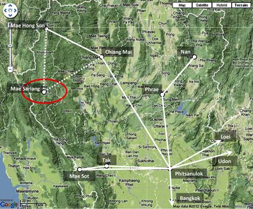
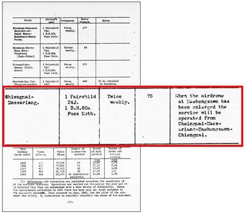
Mae Sariang was included in Airmail Routes operating in Northwest Thailand in 1941:[1a]
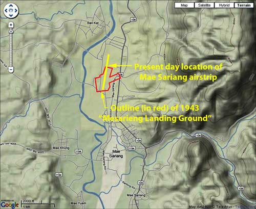
An outline of the location of the Mae Sariang property in 1943 overlaid on a current Nations Online view of Mae Sariang airstrip:[2]
The Mae Sariang airstrip was developed by Thailand's Aerial Transport Company to expand its mail and passenger service.[3] Allied intelligence reported the Mae Sariang airstrip functioning by June 1940, with the comment that service would be expanded to Mae Hong Son when facilities there were completed.[4] Young in Aerial Nationalism writes that flights were planned during 1940 to go from Chiang Mai to Mae Hong Son via Mae Sariang;[5] but contradictively presents a map with the Chiang Mai-Mae Hong Son route functioning in 1939, with no mention of Mae Sariang.[6] In any case, the Transport Company apparently provided air service to Mae Sariang until its plane on that route was shot down by Allied aircraft in March 1945.[7] There is no mention of the airstrip being used by the Royal Thai Air Force in its official histories.[8] The official Japanese history of the war does not mention Mae Sariang, nor show it on associated maps.[9] The Journal on Collection of Japanese War Dead: Burma, India, Thailand reported that hundreds of IJA troops withdrawing from Burma died in the Mae Sariang area, but mentions the airstrip only in passing.[9a]
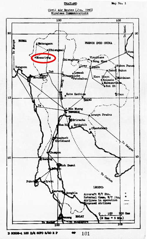
Mae Sariang Chronology Allied pre-war intelligence evaluation: published 15 March 1941 January 1940 (section date): Thai Civil Air Routes[10]
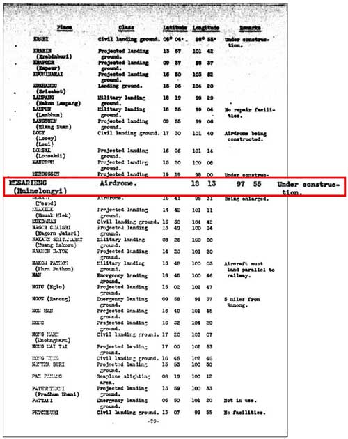
April 1940 (section date) Listed under additional airdromes, landing grounds, and seaplane facilities:[11]
Civil aviation, Operations[12]
|
See Key for interpreting page content. Revision list. See bottom of Text column on next page. 0.^ Per Google Earth. 1.^ Mae Sariang: also rendered Mesarieng, Hminelongyi (name was changed from Muang Yuam in 1917: that name being derived from the river flowing through the town [added 13 May 2015]). 1a.^ "Terrain" map from Nations Online Project: Searchable Map and Satellite View of Thailand using Google Earth Data; accessed 20 May 2012. Annotations by author combine information from Young, Edward, Aerial Nationalism (Washington: Smithsonian Institute, 1995), p ix, and A Survey of Thailand (Siam), (Washington: US War Department, March 15, 1941) p 101, "Civil Air Routes (Jan 1940)", (USAF Archive Reel B1750, p1811). Solid white lines are per Young. Dotted lines are an additional route per US War Department: Young does not show Mae Sariang and connecting air routes. 2.^ Outline lifted from Mae Sariang L/G (Landing Ground) Allied aerial photo dated 24 Jan 1944, in Airfield Report No. 21 (Chief Intelligence Officer, Headquarters, Air Command, South East Asia, Jan 1944), unnumbered page (USAF Archive Reel B8055, p 0646); and overlaid on "Terrain map" from Nations Online Project: Searchable Map and Satellite View of Thailand using Google Earth Data (accessed 20 May 2012). Matching and annotations by author using Microsoft Publisher. 3.^ Young, EM, Aerial Nationalism (Washington: Smithsonian, 1995), p 101. 4.^ A Survey of Thailand (Siam) (Washington: US War Department, 15 March 1941), Section 45. Civil aviation,
f. National air service
(3) Operations, p 25 5.^ Young, ibid, p 101. 6.^ ibid, p ix. 7.^ Christopher Shores, Air War for Burma (London: Grub Street, 2005), p 342. There are several versions of this story. See 20 Mar 1945 on next page. 8.^ ประวัติกองทัพอากาศไทย 9.^ 戦史叢書 (東京: 防衛庁防衛研修所戦史室 (編集), ----年) [Senshi Sosho (Tokyo: Defense Agency, National Defense College Military History Room, various dates)] 9a.^ 戦没者遺骨収集の記録 ピルマ・インド・タイ [Journal on Collection of Japanese War Dead: Burma, India, Thailand] (Tokyo: All Burma Comrades Organization, 1980), hereafter, Journal, p 455. 10.^ A Survey of Thailand (Siam), ibid, Appendix III (untitled), Map No. 1, p 101 (USAF Archive microfilm reel A2874 p 1467) [note that B1750 p 1823 duplicates this].
11.^ ibid, v. Additional Airdromes, Landing Grounds and Seaplane Facilities of Thailand, p 89 (USAF Archive microfilm reel A2874 p 1455).
12.^ ibid, Section 45. Civil aviation, f. National air service, (3) Operations.
|